Wâlterswâld geodata
Wâlterswâld (Friesland) is a populated place; located in Netherlands in Europe/Amsterdam (GMT+2) time zone. With population of 915 people, there are 1449 cities with bigger population in this country. Compared to other cities in Netherlands, 97.5% of cities are located further ↓South; 74.7% of cities are located further ←West and 83.9% of cities have higher elevation than Wâlterswâld. Note1


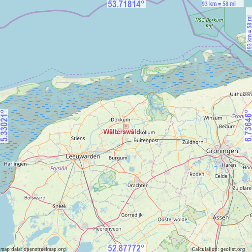
Wâlterswâld GPS coordinates[2]
53° 18' 0" North, 6° 1' 59.988" East
| Map corner | latitude | longitude |
|---|---|---|
| Upper-left | 53.71814°, | 5.33021° |
| Center: | 53.3°, | 6.03333° |
| Lower-right: | 52.87772°, | 6.73646° |
| Map W x H: | 93.4×93.4 km | = 58×58mi |
| max Lat: | 53.48025° ⇑2.5% North |
| Wâlterswâld: | 53.3° |
| min Lat: | ⇓97.5% South 50.76917° |
| min Long | Wâlterswâld | max Long |
| 3.38611° | 6.03333° | 7.16528° |
| W 74.7%⇐ | ⇒25.3% E |
Elevation
Elevation of Wâlterswâld is 1 m = 3 ft, and this is 14 m = 46 ft below average elevation for this country.
| Max E: |
203 m = 666 ft | 83.9% |
| Avg. | 15 m = 49 ft | |
| Wâlterswâld | 1 m = 3 ft | |
Min E: |
-6 m = -20 ft | 16.1% |
See also: Netherlands elevation on elevation.city.
Geographical zone
Wâlterswâld is located in North temperate zone (between Tropic of Cancer and the Arctic Circle). Distance of this North polar circle is 1474.8 km =916.4 mi to North.| Distance of | km | miles | from Wâlterswâld |
|---|---|---|---|
| North Pole | 4080.7 | 2535.6 | to North |
| Arctic Circle | 1474.8 | 916.4 | to North |
| Tropic Cancer | 3320.5 | 2063.3 | to South |
| Equator | 5926.4 | 3682.5 | to South |


Nearby cities:
15 places around Wâlterswâld: (largest is in red/bold)
• Broeksterwâld
3.7 km =2.3 mi,  221°
221°
• Damwâld
2.6 km =1.6 mi,  245°
245°
• De Westereen
4.8 km =3 mi,  177°
177°
• Dokkum
3.5 km =2.2 mi,  315°
315°
• Driezum
1 km =0.6 mi,  118°
118°
• Ee
5.6 km =3.5 mi,  52°
52°
• Feanwâlden
7.8 km =4.8 mi,  202°
202°
• Kollum
8.4 km =5.2 mi,  107°
107°
• Kollumerzwaag
5 km =3.1 mi,  146°
146°
• Metslawier
7 km =4.3 mi,  18°
18°
• Oudwoude
5.8 km =3.6 mi, 110°
• Rinsumageast
5.6 km =3.5 mi,  266°
266°
• Twijzel
8.5 km =5.3 mi, 153°
• Twijzelerheide
6.7 km =4.2 mi,  172°
172°
• Zwagerbosch
5.8 km =3.6 mi, 170°
Sources, notices
• [Note1] Compared only with cities in Netherlands existing in our database
• [Src1] Map data: © OpenStreetMap contributors (CC-BY-SA)
• [Src2] Other city data from geonames.org with taken over terms of usage.
• [Src3] Geographical zone / Annual Mean Temperature by Robert A. Rohde @ Wikipedia
