Driezum geodata
Driezum (Friesland) is a populated place; located in Netherlands in Europe/Amsterdam (GMT+2) time zone. With population of 840 people, there are 1501 cities with bigger population in this country. Compared to other cities in Netherlands, 97.3% of cities are located further ↓South; 75.7% of cities are located further ←West and 65.8% of cities have higher elevation than Driezum. Note1


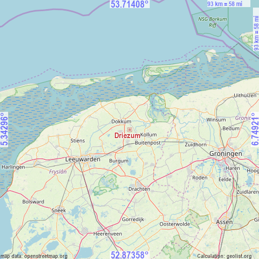
Driezum GPS coordinates[2]
53° 17' 45.24" North, 6° 2' 45.924" East
| Map corner | latitude | longitude |
|---|---|---|
| Upper-left | 53.71408°, | 5.34296° |
| Center: | 53.2959°, | 6.04609° |
| Lower-right: | 52.87358°, | 6.74921° |
| Map W x H: | 93.5×93.5 km | = 58.1×58.1mi |
| max Lat: | 53.48025° ⇑2.7% North |
| Driezum: | 53.2959° |
| min Lat: | ⇓97.3% South 50.76917° |
| min Long | Driezum | max Long |
| 3.38611° | 6.04609° | 7.16528° |
| W 75.7%⇐ | ⇒24.3% E |
Elevation
Elevation of Driezum is 3 m = 10 ft, and this is 12 m = 39 ft below average elevation for this country.
| Max E: |
203 m = 666 ft | 65.8% |
| Avg. | 15 m = 49 ft | |
| Driezum | 3 m = 10 ft | |
Min E: |
-6 m = -20 ft | 34.2% |
See also: Netherlands elevation on elevation.city.
Geographical zone
Driezum is located in North temperate zone (between Tropic of Cancer and the Arctic Circle). Distance of this North polar circle is 1475.2 km =916.6 mi to North.| Distance of | km | miles | from Driezum |
|---|---|---|---|
| North Pole | 4081.1 | 2535.9 | to North |
| Arctic Circle | 1475.2 | 916.6 | to North |
| Tropic Cancer | 3320 | 2063 | to South |
| Equator | 5925.9 | 3682.2 | to South |


Nearby cities:
15 places around Driezum: (largest is in red/bold)
• Broeksterwâld
4.1 km =2.5 mi,  234°
234°
• Damwâld
3.3 km =2.1 mi,  259°
259°
• De Westereen
4.3 km =2.7 mi,  188°
188°
• Dokkum
4.4 km =2.7 mi,  311°
311°
• Ee
5.3 km =3.3 mi,  43°
43°
• Feanwâlden
7.7 km =4.8 mi,  209°
209°
• Kollum
7.4 km =4.6 mi,  106°
106°
• Kollumerzwaag
4.2 km =2.6 mi,  152°
152°
• Metslawier
7.2 km =4.5 mi,  11°
11°
• Oudwoude
4.8 km =3 mi, 108°
• Rinsumageast
6.4 km =4 mi,  271°
271°
• Twijzel
7.7 km =4.8 mi,  158°
158°
• Twijzelerheide
6.2 km =3.9 mi,  180°
180°
• Wâlterswâld
1 km =0.6 mi,  298°
298°
• Zwagerbosch
5.3 km =3.3 mi, 179°
Sources, notices
• [Note1] Compared only with cities in Netherlands existing in our database
• [Src1] Map data: © OpenStreetMap contributors (CC-BY-SA)
• [Src2] Other city data from geonames.org with taken over terms of usage.
• [Src3] Geographical zone / Annual Mean Temperature by Robert A. Rohde @ Wikipedia
