Kollumerzwaag geodata
Kollumerzwaag (Friesland) is a populated place; located in Netherlands in Europe/Amsterdam (GMT+2) time zone. With population of 2,805 people, there are 786 cities with bigger population in this country. Compared to other cities in Netherlands, 96.2% of cities are located further ↓South; 78% of cities are located further ←West and 65.8% of cities have higher elevation than Kollumerzwaag. Note1


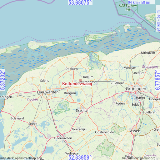
Kollumerzwaag GPS coordinates[2]
53° 15' 44.064" North, 6° 4' 31.584" East
| Map corner | latitude | longitude |
|---|---|---|
| Upper-left | 53.68075°, | 5.37232° |
| Center: | 53.26224°, | 6.07544° |
| Lower-right: | 52.83959°, | 6.77857° |
| Map W x H: | 93.5×93.5 km | = 58.1×58.1mi |
| max Lat: | 53.48025° ⇑3.8% North |
| Kollumerzwaag: | 53.26224° |
| min Lat: | ⇓96.2% South 50.76917° |
| min Long | Kollumerzwaag | max Long |
| 3.38611° | 6.07544° | 7.16528° |
| W 78%⇐ | ⇒22% E |
Elevation
Elevation of Kollumerzwaag is 3 m = 10 ft, and this is 12 m = 39 ft below average elevation for this country.
| Max E: |
203 m = 666 ft | 65.8% |
| Avg. | 15 m = 49 ft | |
| Kollumerzwaag | 3 m = 10 ft | |
Min E: |
-6 m = -20 ft | 34.2% |
See also: Netherlands elevation on elevation.city.
Geographical zone
Kollumerzwaag is located in North temperate zone (between Tropic of Cancer and the Arctic Circle). Distance of this North polar circle is 1479 km =919 mi to North.| Distance of | km | miles | from Kollumerzwaag |
|---|---|---|---|
| North Pole | 4084.9 | 2538.2 | to North |
| Arctic Circle | 1479 | 919 | to North |
| Tropic Cancer | 3316.3 | 2060.7 | to South |
| Equator | 5922.2 | 3679.9 | to South |


Nearby cities:
15 places around Kollumerzwaag: (largest is in red/bold)
• Broeksterwâld
5.4 km =3.4 mi,  284°
284°
• Buitenpost
4.8 km =3 mi,  104°
104°
• Damwâld
6 km =3.7 mi,  301°
301°
• De Westereen
2.7 km =1.7 mi,  258°
258°
• Driezum
4.2 km =2.6 mi,  332°
332°
• Feanwâlden
6.5 km =4 mi,  242°
242°
• Jistrum
5.7 km =3.5 mi,  185°
185°
• Kollum
5.4 km =3.4 mi,  72°
72°
• Kootstertille
5.6 km =3.5 mi,  168°
168°
• Noardburgum
6.5 km =4 mi,  225°
225°
• Oudwoude
3.4 km =2.1 mi,  49°
49°
• Twijzel
3.5 km =2.2 mi,  164°
164°
• Twijzelerheide
3.1 km =1.9 mi,  218°
218°
• Wâlterswâld
5 km =3.1 mi, 326°
• Zwagerbosch
2.4 km =1.5 mi, 229°
Sources, notices
• [Note1] Compared only with cities in Netherlands existing in our database
• [Src1] Map data: © OpenStreetMap contributors (CC-BY-SA)
• [Src2] Other city data from geonames.org with taken over terms of usage.
• [Src3] Geographical zone / Annual Mean Temperature by Robert A. Rohde @ Wikipedia
