Oudwoude geodata
Oudwoude (Friesland) is a populated place; located in Netherlands in Europe/Amsterdam (GMT+2) time zone. With population of 635 people, there are 1680 cities with bigger population in this country. Compared to other cities in Netherlands, 97% of cities are located further ↓South; 80.1% of cities are located further ←West and 74.9% of cities have higher elevation than Oudwoude. Note1


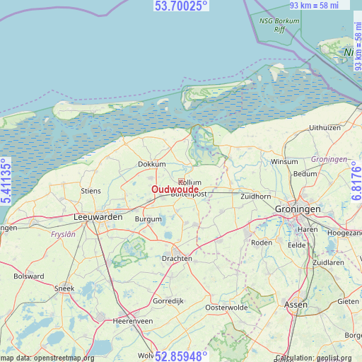
Oudwoude GPS coordinates[2]
53° 16' 54.948" North, 6° 6' 52.092" East
| Map corner | latitude | longitude |
|---|---|---|
| Upper-left | 53.70025°, | 5.41135° |
| Center: | 53.28193°, | 6.11447° |
| Lower-right: | 52.85948°, | 6.8176° |
| Map W x H: | 93.5×93.5 km | = 58.1×58.1mi |
| max Lat: | 53.48025° ⇑3% North |
| Oudwoude: | 53.28193° |
| min Lat: | ⇓97% South 50.76917° |
| min Long | Oudwoude | max Long |
| 3.38611° | 6.11447° | 7.16528° |
| W 80.1%⇐ | ⇒19.9% E |
Elevation
Elevation of Oudwoude is 2 m = 7 ft, and this is 13 m = 43 ft below average elevation for this country.
| Max E: |
203 m = 666 ft | 74.9% |
| Avg. | 15 m = 49 ft | |
| Oudwoude | 2 m = 7 ft | |
Min E: |
-6 m = -20 ft | 25.1% |
See also: Netherlands elevation on elevation.city.
Geographical zone
Oudwoude is located in North temperate zone (between Tropic of Cancer and the Arctic Circle). Distance of this North polar circle is 1476.8 km =917.6 mi to North.| Distance of | km | miles | from Oudwoude |
|---|---|---|---|
| North Pole | 4082.7 | 2536.9 | to North |
| Arctic Circle | 1476.8 | 917.6 | to North |
| Tropic Cancer | 3318.5 | 2062 | to South |
| Equator | 5924.4 | 3681.3 | to South |


Nearby cities:
15 places around Oudwoude: (largest is in red/bold)
• Augustinusga
7.8 km =4.8 mi,  156°
156°
• Buitenpost
3.9 km =2.4 mi,  149°
149°
• Burum
7.7 km =4.8 mi,  97°
97°
• Damwâld
7.8 km =4.8 mi,  276°
276°
• De Westereen
5.9 km =3.7 mi,  242°
242°
• Driezum
4.8 km =3 mi,  288°
288°
• Ee
5.5 km =3.4 mi,  350°
350°
• Gerkesklooster
7.7 km =4.8 mi,  129°
129°
• Kollum
2.6 km =1.6 mi, 102°
• Kollumerzwaag
3.4 km =2.1 mi,  229°
229°
• Kootstertille
7.9 km =4.9 mi,  190°
190°
• Twijzel
5.8 km =3.6 mi,  196°
196°
• Twijzelerheide
6.5 km =4 mi,  224°
224°
• Wâlterswâld
5.8 km =3.6 mi, 290°
• Zwagerbosch
5.8 km =3.6 mi, 229°
Sources, notices
• [Note1] Compared only with cities in Netherlands existing in our database
• [Src1] Map data: © OpenStreetMap contributors (CC-BY-SA)
• [Src2] Other city data from geonames.org with taken over terms of usage.
• [Src3] Geographical zone / Annual Mean Temperature by Robert A. Rohde @ Wikipedia
