Franeker geodata
Franeker (Friesland) is a populated place; located in Netherlands in Europe/Amsterdam (GMT+2) time zone. With population of 12,996 people, there are 236 cities with bigger population in this country. Compared to other cities in Netherlands, 92.5% of cities are located further ↓South; 55.3% of cities are located further →East and 58.8% of cities have higher elevation than Franeker. Note1


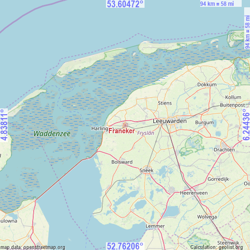
Franeker GPS coordinates[2]
53° 11' 7.656" North, 5° 32' 28.428" East
| Map corner | latitude | longitude |
|---|---|---|
| Upper-left | 53.60472°, | 4.83811° |
| Center: | 53.18546°, | 5.54123° |
| Lower-right: | 52.76206°, | 6.24436° |
| Map W x H: | 93.7×93.7 km | = 58.2×58.2mi |
| max Lat: | 53.48025° ⇑7.5% North |
| Franeker: | 53.18546° |
| min Lat: | ⇓92.5% South 50.76917° |
| min Long | Franeker | max Long |
| 3.38611° | 5.54123° | 7.16528° |
| W 44.7%⇐ | ⇒55.3% E |
Elevation
Elevation of Franeker is 4 m = 13 ft, and this is 11 m = 36 ft below average elevation for this country.
| Max E: |
203 m = 666 ft | 58.8% |
| Avg. | 15 m = 49 ft | |
| Franeker | 4 m = 13 ft | |
Min E: |
-6 m = -20 ft | 41.2% |
See also: Netherlands elevation on elevation.city.
Geographical zone
Franeker is located in North temperate zone (between Tropic of Cancer and the Arctic Circle). Distance of this North polar circle is 1487.5 km =924.3 mi to North.| Distance of | km | miles | from Franeker |
|---|---|---|---|
| North Pole | 4093.4 | 2543.5 | to North |
| Arctic Circle | 1487.5 | 924.3 | to North |
| Tropic Cancer | 3307.7 | 2055.3 | to South |
| Equator | 5913.7 | 3674.6 | to South |


Nearby cities:
15 places around Franeker: (largest is in red/bold)
• Achlum
5.6 km =3.5 mi,  223°
223°
• Arum
7.6 km =4.7 mi,  214°
214°
• Berltsum
9.8 km =6.1 mi,  48°
48°
• Dronryp
7.4 km =4.6 mi,  77°
77°
• Harlingen
8 km =5 mi,  261°
261°
• Menaam
8.8 km =5.5 mi,  65°
65°
• Midlum
6.2 km =3.9 mi,  266°
266°
• Minnertsga
8.1 km =5 mi,  26°
26°
• Sexbierum
5.3 km =3.3 mi,  313°
313°
• Sint Jacobiparochie
10.6 km =6.6 mi,  23°
23°
• Tzum
3.3 km =2.1 mi,  153°
153°
• Tzummarum
5.8 km =3.6 mi,  3°
3°
• Winsum
7.2 km =4.5 mi,  121°
121°
• Witmarsum
10.2 km =6.3 mi, 208°
• Wommels
9.1 km =5.7 mi,  160°
160°
Sources, notices
• [Note1] Compared only with cities in Netherlands existing in our database
• [Src1] Map data: © OpenStreetMap contributors (CC-BY-SA)
• [Src2] Other city data from geonames.org with taken over terms of usage.
• [Src3] Geographical zone / Annual Mean Temperature by Robert A. Rohde @ Wikipedia
