Werkhoven geodata
Werkhoven (Utrecht) is a populated place; located in Netherlands in Europe/Amsterdam (GMT+2) time zone. With population of 1,990 people, there are 963 cities with bigger population in this country. Compared to other cities in Netherlands, 50.4% of cities are located further ↓South; 65.2% of cities are located further →East and 50.6% of cities have higher elevation than Werkhoven. Note1


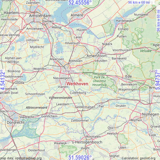
Werkhoven GPS coordinates[2]
52° 1' 30" North, 5° 14' 39.984" East
| Map corner | latitude | longitude |
|---|---|---|
| Upper-left | 52.45556°, | 4.54132° |
| Center: | 52.025°, | 5.24444° |
| Lower-right: | 51.59026°, | 5.94757° |
| Map W x H: | 96.2×96.2 km | = 59.8×59.8mi |
| max Lat: | 53.48025° ⇑49.6% North |
| Werkhoven: | 52.025° |
| min Lat: | ⇓50.4% South 50.76917° |
| min Long | Werkhoven | max Long |
| 3.38611° | 5.24444° | 7.16528° |
| W 34.8%⇐ | ⇒65.2% E |
Elevation
Elevation of Werkhoven is 6 m = 20 ft, and this is 9 m = 30 ft below average elevation for this country.
| Max E: |
203 m = 666 ft | 50.6% |
| Avg. | 15 m = 49 ft | |
| Werkhoven | 6 m = 20 ft | |
Min E: |
-6 m = -20 ft | 49.4% |
See also: Netherlands elevation on elevation.city.
Geographical zone
Werkhoven is located in North temperate zone (between Tropic of Cancer and the Arctic Circle). Distance of this North polar circle is 1616.5 km =1004.4 mi to North.| Distance of | km | miles | from Werkhoven |
|---|---|---|---|
| North Pole | 4222.4 | 2623.7 | to North |
| Arctic Circle | 1616.5 | 1004.4 | to North |
| Tropic Cancer | 3178.7 | 1975.2 | to South |
| Equator | 5784.6 | 3594.4 | to South |


Nearby cities:
15 places around Werkhoven: (largest is in red/bold)
• Austerlitz
7.8 km =4.8 mi,  38°
38°
• Beusichem
8.9 km =5.5 mi,  158°
158°
• Bunnik
5.6 km =3.5 mi,  325°
325°
• Cothen
5.4 km =3.4 mi,  125°
125°
• Culemborg
7.9 km =4.9 mi,  188°
188°
• De Uithof
8.2 km =5.1 mi,  324°
324°
• Doorn
7 km =4.3 mi,  82°
82°
• Driebergen-Rijsenburg
4 km =2.5 mi, 38°
• Houten
5.2 km =3.2 mi,  274°
274°
• Kerckebosch
6.1 km =3.8 mi,  13°
13°
• Lunetten
8.5 km =5.3 mi,  298°
298°
• Nijenheim
7.1 km =4.4 mi,  345°
345°
• Odijk
3.1 km =1.9 mi, 349°
• Wijk bij Duurstede
8.7 km =5.4 mi, 130°
• Zeist
7.3 km =4.5 mi, 354°
Sources, notices
• [Note1] Compared only with cities in Netherlands existing in our database
• [Src1] Map data: © OpenStreetMap contributors (CC-BY-SA)
• [Src2] Other city data from geonames.org with taken over terms of usage.
• [Src3] Geographical zone / Annual Mean Temperature by Robert A. Rohde @ Wikipedia
