Lunetten geodata
Lunetten (Utrecht) is a section of populated place; located in Netherlands in Europe/Amsterdam (GMT+2) time zone. With population of 11,679 people, there are 262 cities with bigger population in this country. Compared to other cities in Netherlands, 52.5% of cities are located further ↓South; 68.9% of cities are located further →East and 58.8% of cities have higher elevation than Lunetten. Note1


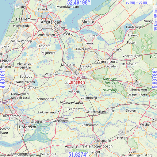
Lunetten GPS coordinates[2]
52° 3' 42.408" North, 5° 8' 5.064" East
| Map corner | latitude | longitude |
|---|---|---|
| Upper-left | 52.49198°, | 4.43161° |
| Center: | 52.06178°, | 5.13474° |
| Lower-right: | 51.6274°, | 5.83786° |
| Map W x H: | 96.1×96.1 km | = 59.7×59.7mi |
| max Lat: | 53.48025° ⇑47.5% North |
| Lunetten: | 52.06178° |
| min Lat: | ⇓52.5% South 50.76917° |
| min Long | Lunetten | max Long |
| 3.38611° | 5.13474° | 7.16528° |
| W 31.1%⇐ | ⇒68.9% E |
Elevation
Elevation of Lunetten is 4 m = 13 ft, and this is 11 m = 36 ft below average elevation for this country.
| Max E: |
203 m = 666 ft | 58.8% |
| Avg. | 15 m = 49 ft | |
| Lunetten | 4 m = 13 ft | |
Min E: |
-6 m = -20 ft | 41.2% |
See also: Netherlands elevation on elevation.city.
Geographical zone
Lunetten is located in North temperate zone (between Tropic of Cancer and the Arctic Circle). Distance of this North polar circle is 1612.4 km =1001.9 mi to North.| Distance of | km | miles | from Lunetten |
|---|---|---|---|
| North Pole | 4218.3 | 2621.1 | to North |
| Arctic Circle | 1612.4 | 1001.9 | to North |
| Tropic Cancer | 3182.8 | 1977.7 | to South |
| Equator | 5788.7 | 3596.9 | to South |


Nearby cities:
15 places around Lunetten: (largest is in red/bold)
• Bunnik
4.4 km =2.7 mi,  82°
82°
• De Bilt
6.2 km =3.9 mi,  30°
30°
• De Hagen
7.9 km =4.9 mi,  196°
196°
• De Uithof
3.8 km =2.4 mi,  46°
46°
• Groenekan
7 km =4.3 mi,  10°
10°
• Houten
4.4 km =2.7 mi,  148°
148°
• IJsselstein
7.8 km =4.8 mi,  233°
233°
• Nieuwegein
5.2 km =3.2 mi, 225°
• Nijenheim
6.4 km =4 mi,  64°
64°
• Odijk
7 km =4.3 mi,  98°
98°
• Oog in Al
4.4 km =2.7 mi,  308°
308°
• Utrecht
3.3 km =2.1 mi,  345°
345°
• Vianen
8.2 km =5.1 mi, 200°
• Vreeswijk
6.3 km =3.9 mi,  206°
206°
• Zeist
7.4 km =4.6 mi,  65°
65°
Sources, notices
• [Note1] Compared only with cities in Netherlands existing in our database
• [Src1] Map data: © OpenStreetMap contributors (CC-BY-SA)
• [Src2] Other city data from geonames.org with taken over terms of usage.
• [Src3] Geographical zone / Annual Mean Temperature by Robert A. Rohde @ Wikipedia
