Bunnik geodata
Bunnik (Utrecht) is a populated place; located in Netherlands in Europe/Amsterdam (GMT+2) time zone. With population of 6,315 people, there are 392 cities with bigger population in this country. Compared to other cities in Netherlands, 52.7% of cities are located further ↓South; 66.5% of cities are located further →East and 58.8% of cities have higher elevation than Bunnik. Note1


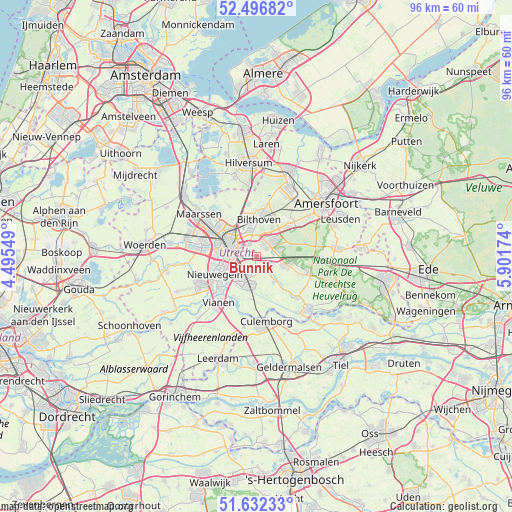
Bunnik GPS coordinates[2]
52° 4' 0.012" North, 5° 11' 54.996" East
| Map corner | latitude | longitude |
|---|---|---|
| Upper-left | 52.49682°, | 4.49549° |
| Center: | 52.06667°, | 5.19861° |
| Lower-right: | 51.63233°, | 5.90174° |
| Map W x H: | 96.1×96.1 km | = 59.7×59.7mi |
| max Lat: | 53.48025° ⇑47.3% North |
| Bunnik: | 52.06667° |
| min Lat: | ⇓52.7% South 50.76917° |
| min Long | Bunnik | max Long |
| 3.38611° | 5.19861° | 7.16528° |
| W 33.5%⇐ | ⇒66.5% E |
Elevation
Elevation of Bunnik is 4 m = 13 ft, and this is 11 m = 36 ft below average elevation for this country.
| Max E: |
203 m = 666 ft | 58.8% |
| Avg. | 15 m = 49 ft | |
| Bunnik | 4 m = 13 ft | |
Min E: |
-6 m = -20 ft | 41.2% |
See also: Netherlands elevation on elevation.city.
Geographical zone
Bunnik is located in North temperate zone (between Tropic of Cancer and the Arctic Circle). Distance of this North polar circle is 1611.9 km =1001.6 mi to North.| Distance of | km | miles | from Bunnik |
|---|---|---|---|
| North Pole | 4217.8 | 2620.8 | to North |
| Arctic Circle | 1611.9 | 1001.6 | to North |
| Tropic Cancer | 3183.4 | 1978.1 | to South |
| Equator | 5789.3 | 3597.3 | to South |


Nearby cities:
15 places around Bunnik: (largest is in red/bold)
• Austerlitz
8.1 km =5 mi,  79°
79°
• Bosch en Duin
6.3 km =3.9 mi,  27°
27°
• De Bilt
5 km =3.1 mi,  345°
345°
• De Uithof
2.6 km =1.6 mi,  321°
321°
• Driebergen-Rijsenburg
5.8 km =3.6 mi,  104°
104°
• Groenekan
7 km =4.3 mi,  333°
333°
• Houten
4.7 km =2.9 mi,  206°
206°
• Kerckebosch
4.8 km =3 mi,  74°
74°
• Lunetten
4.4 km =2.7 mi,  262°
262°
• Nijenheim
2.6 km =1.6 mi, 31°
• Odijk
3 km =1.9 mi,  121°
121°
• Sterrenberg
7.8 km =4.8 mi,  47°
47°
• Utrecht
5.9 km =3.7 mi,  297°
297°
• Werkhoven
5.6 km =3.5 mi,  145°
145°
• Zeist
3.5 km =2.2 mi,  42°
42°
Sources, notices
• [Note1] Compared only with cities in Netherlands existing in our database
• [Src1] Map data: © OpenStreetMap contributors (CC-BY-SA)
• [Src2] Other city data from geonames.org with taken over terms of usage.
• [Src3] Geographical zone / Annual Mean Temperature by Robert A. Rohde @ Wikipedia
