Houten geodata
Houten (Utrecht) is a populated place; located in Netherlands in Europe/Amsterdam (GMT+2) time zone. With population of 1,335 people, there are 1217 cities with bigger population in this country. Compared to other cities in Netherlands, 50.6% of cities are located further ↓South; 67.6% of cities are located further →East and 65.8% of cities have higher elevation than Houten. Note1


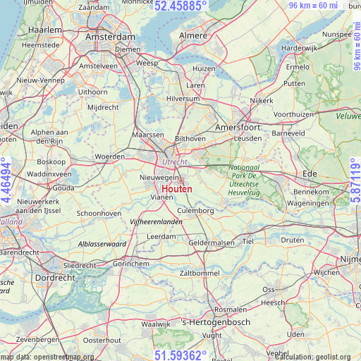
Houten GPS coordinates[2]
52° 1' 41.988" North, 5° 10' 5.016" East
| Map corner | latitude | longitude |
|---|---|---|
| Upper-left | 52.45885°, | 4.46494° |
| Center: | 52.02833°, | 5.16806° |
| Lower-right: | 51.59362°, | 5.87119° |
| Map W x H: | 96.2×96.2 km | = 59.8×59.8mi |
| max Lat: | 53.48025° ⇑49.4% North |
| Houten: | 52.02833° |
| min Lat: | ⇓50.6% South 50.76917° |
| min Long | Houten | max Long |
| 3.38611° | 5.16806° | 7.16528° |
| W 32.4%⇐ | ⇒67.6% E |
Elevation
Elevation of Houten is 3 m = 10 ft, and this is 12 m = 39 ft below average elevation for this country.
| Max E: |
203 m = 666 ft | 65.8% |
| Avg. | 15 m = 49 ft | |
| Houten | 3 m = 10 ft | |
Min E: |
-6 m = -20 ft | 34.2% |
See also: Netherlands elevation on elevation.city.
Geographical zone
Houten is located in North temperate zone (between Tropic of Cancer and the Arctic Circle). Distance of this North polar circle is 1616.2 km =1004.3 mi to North.| Distance of | km | miles | from Houten |
|---|---|---|---|
| North Pole | 4222.1 | 2623.5 | to North |
| Arctic Circle | 1616.2 | 1004.3 | to North |
| Tropic Cancer | 3179.1 | 1975.4 | to South |
| Equator | 5785 | 3594.6 | to South |


Nearby cities:
15 places around Houten: (largest is in red/bold)
• Bunnik
4.7 km =2.9 mi,  26°
26°
• De Hagen
5.9 km =3.7 mi,  229°
229°
• De Uithof
6.3 km =3.9 mi,  4°
4°
• Driebergen-Rijsenburg
8.2 km =5.1 mi,  70°
70°
• Everdingen
7.1 km =4.4 mi,  186°
186°
• Hagestein
6.1 km =3.8 mi,  210°
210°
• Lunetten
4.4 km =2.7 mi,  328°
328°
• Nieuwegein
6 km =3.7 mi,  270°
270°
• Nijenheim
7.4 km =4.6 mi, 27°
• Odijk
5.4 km =3.4 mi,  59°
59°
• Utrecht
7.6 km =4.7 mi,  335°
335°
• Vianen
6.6 km =4.1 mi, 232°
• Vreeswijk
5.5 km =3.4 mi,  249°
249°
• Werkhoven
5.2 km =3.2 mi,  94°
94°
• Zeist
8.2 km =5.1 mi, 33°
Sources, notices
• [Note1] Compared only with cities in Netherlands existing in our database
• [Src1] Map data: © OpenStreetMap contributors (CC-BY-SA)
• [Src2] Other city data from geonames.org with taken over terms of usage.
• [Src3] Geographical zone / Annual Mean Temperature by Robert A. Rohde @ Wikipedia
