Wapenveld geodata
Wapenveld (Gelderland) is a populated place; located in Netherlands in Europe/Amsterdam (GMT+2) time zone. With population of 3,995 people, there are 587 cities with bigger population in this country. Compared to other cities in Netherlands, 69.6% of cities are located further ↓South; 77.7% of cities are located further ←West and 50.6% of cities have higher elevation than Wapenveld. Note1


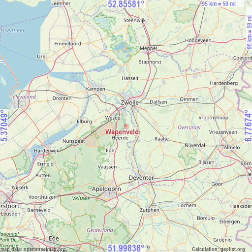
Wapenveld GPS coordinates[2]
52° 25' 45.012" North, 6° 4' 24.996" East
| Map corner | latitude | longitude |
|---|---|---|
| Upper-left | 52.85581°, | 5.37049° |
| Center: | 52.42917°, | 6.07361° |
| Lower-right: | 51.99836°, | 6.77674° |
| Map W x H: | 95.3×95.3 km | = 59.2×59.2mi |
| max Lat: | 53.48025° ⇑30.4% North |
| Wapenveld: | 52.42917° |
| min Lat: | ⇓69.6% South 50.76917° |
| min Long | Wapenveld | max Long |
| 3.38611° | 6.07361° | 7.16528° |
| W 77.7%⇐ | ⇒22.3% E |
Elevation
Elevation of Wapenveld is 6 m = 20 ft, and this is 9 m = 30 ft below average elevation for this country.
| Max E: |
203 m = 666 ft | 50.6% |
| Avg. | 15 m = 49 ft | |
| Wapenveld | 6 m = 20 ft | |
Min E: |
-6 m = -20 ft | 49.4% |
See also: Netherlands elevation on elevation.city.
Geographical zone
Wapenveld is located in North temperate zone (between Tropic of Cancer and the Arctic Circle). Distance of this North polar circle is 1571.6 km =976.5 mi to North.| Distance of | km | miles | from Wapenveld |
|---|---|---|---|
| North Pole | 4177.5 | 2595.8 | to North |
| Arctic Circle | 1571.6 | 976.5 | to North |
| Tropic Cancer | 3223.7 | 2003.1 | to South |
| Equator | 5829.6 | 3622.3 | to South |


Nearby cities:
15 places around Wapenveld: (largest is in red/bold)
• Broekdijk
9.8 km =6.1 mi,  283°
283°
• Elshof
9.5 km =5.9 mi,  114°
114°
• Epe
11 km =6.8 mi,  214°
214°
• Frankhuis
10.7 km =6.6 mi,  357°
357°
• Hattem
5.1 km =3.2 mi,  352°
352°
• Hattemerbroek
6.1 km =3.8 mi,  325°
325°
• Heerde
5.2 km =3.2 mi, 205°
• Heino
10.8 km =6.7 mi,  85°
85°
• Oene
9.6 km =6 mi,  190°
190°
• Olst
10.5 km =6.5 mi,  166°
166°
• Pierik
8.4 km =5.2 mi,  17°
17°
• Welsum
10.5 km =6.5 mi, 173°
• Wijhe
6.3 km =3.9 mi,  138°
138°
• Wijthmen
9.2 km =5.7 mi,  45°
45°
• Zwolle
9.4 km =5.8 mi,  8°
8°
Sources, notices
• [Note1] Compared only with cities in Netherlands existing in our database
• [Src1] Map data: © OpenStreetMap contributors (CC-BY-SA)
• [Src2] Other city data from geonames.org with taken over terms of usage.
• [Src3] Geographical zone / Annual Mean Temperature by Robert A. Rohde @ Wikipedia
