Wijhe geodata
Wijhe (Overijssel) is a populated place; located in Netherlands in Europe/Amsterdam (GMT+2) time zone. With population of 5,640 people, there are 433 cities with bigger population in this country. Compared to other cities in Netherlands, 68.9% of cities are located further ↓South; 80.8% of cities are located further ←West and 52.4% of cities have lower elevation than Wijhe. Note1


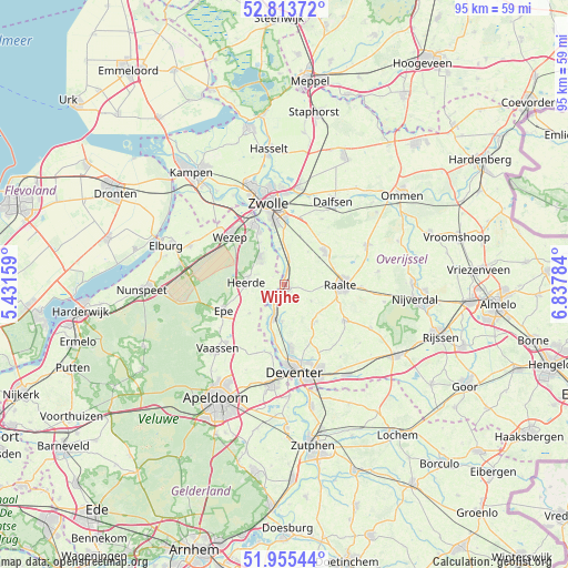
Wijhe GPS coordinates[2]
52° 23' 12.012" North, 6° 8' 4.992" East
| Map corner | latitude | longitude |
|---|---|---|
| Upper-left | 52.81372°, | 5.43159° |
| Center: | 52.38667°, | 6.13472° |
| Lower-right: | 51.95544°, | 6.83784° |
| Map W x H: | 95.4×95.4 km | = 59.3×59.3mi |
| max Lat: | 53.48025° ⇑31.1% North |
| Wijhe: | 52.38667° |
| min Lat: | ⇓68.9% South 50.76917° |
| min Long | Wijhe | max Long |
| 3.38611° | 6.13472° | 7.16528° |
| W 80.8%⇐ | ⇒19.2% E |
Elevation
Elevation of Wijhe is 7 m = 23 ft, and this is 8 m = 26 ft below average elevation for this country.
| Max E: |
203 m = 666 ft | 47.6% |
| Avg. | 15 m = 49 ft | |
| Wijhe | 7 m = 23 ft | |
Min E: |
-6 m = -20 ft | 52.4% |
See also: Netherlands elevation on elevation.city.
Geographical zone
Wijhe is located in North temperate zone (between Tropic of Cancer and the Arctic Circle). Distance of this North polar circle is 1576.3 km =979.5 mi to North.| Distance of | km | miles | from Wijhe |
|---|---|---|---|
| North Pole | 4182.2 | 2598.7 | to North |
| Arctic Circle | 1576.3 | 979.5 | to North |
| Tropic Cancer | 3218.9 | 2000.1 | to South |
| Equator | 5824.9 | 3619.4 | to South |


Nearby cities:
15 places around Wijhe: (largest is in red/bold)
• Borgele
12.3 km =7.6 mi,  175°
175°
• Boskamp
6.2 km =3.9 mi, 184°
• Elshof
4.5 km =2.8 mi,  80°
80°
• Epe
11.2 km =7 mi,  247°
247°
• Hattem
10.9 km =6.8 mi,  333°
333°
• Hattemerbroek
12.4 km =7.7 mi,  321°
321°
• Heerde
6.4 km =4 mi,  270°
270°
• Heino
8.7 km =5.4 mi,  50°
50°
• Oene
7.5 km =4.7 mi,  231°
231°
• Olst
5.7 km =3.5 mi,  197°
197°
• Raalte
9.5 km =5.9 mi,  90°
90°
• Terwolde
11.7 km =7.3 mi,  191°
191°
• Wapenveld
6.3 km =3.9 mi, 318°
• Welsum
6.4 km =4 mi,  207°
207°
• Wijthmen
11.5 km =7.1 mi,  12°
12°
Sources, notices
• [Note1] Compared only with cities in Netherlands existing in our database
• [Src1] Map data: © OpenStreetMap contributors (CC-BY-SA)
• [Src2] Other city data from geonames.org with taken over terms of usage.
• [Src3] Geographical zone / Annual Mean Temperature by Robert A. Rohde @ Wikipedia
