Den Ham geodata
Den Ham (Overijssel) is a populated place; located in Netherlands in Europe/Amsterdam (GMT+2) time zone. With population of 1,830 people, there are 1014 cities with bigger population in this country. Compared to other cities in Netherlands, 70.7% of cities are located further ↓South; 88.5% of cities are located further ←West and 55.1% of cities have lower elevation than Den Ham. Note1


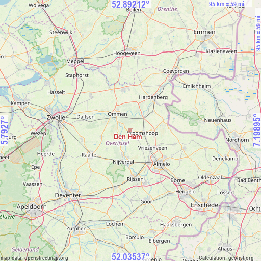
Den Ham GPS coordinates[2]
52° 27' 56.988" North, 6° 29' 44.988" East
| Map corner | latitude | longitude |
|---|---|---|
| Upper-left | 52.89212°, | 5.7927° |
| Center: | 52.46583°, | 6.49583° |
| Lower-right: | 52.03537°, | 7.19895° |
| Map W x H: | 95.3×95.3 km | = 59.2×59.2mi |
| max Lat: | 53.48025° ⇑29.3% North |
| Den Ham: | 52.46583° |
| min Lat: | ⇓70.7% South 50.76917° |
| min Long | Den Ham | max Long |
| 3.38611° | 6.49583° | 7.16528° |
| W 88.5%⇐ | ⇒11.5% E |
Elevation
Elevation of Den Ham is 8 m = 26 ft, and this is 7 m = 23 ft below average elevation for this country.
| Max E: |
203 m = 666 ft | 44.9% |
| Avg. | 15 m = 49 ft | |
| Den Ham | 8 m = 26 ft | |
Min E: |
-6 m = -20 ft | 55.1% |
See also: Netherlands elevation on elevation.city.
Geographical zone
Den Ham is located in North temperate zone (between Tropic of Cancer and the Arctic Circle). Distance of this North polar circle is 1567.5 km =974 mi to North.| Distance of | km | miles | from Den Ham |
|---|---|---|---|
| North Pole | 4173.4 | 2593.2 | to North |
| Arctic Circle | 1567.5 | 974 | to North |
| Tropic Cancer | 3227.7 | 2005.6 | to South |
| Equator | 5833.7 | 3624.9 | to South |


Nearby cities:
15 places around Den Ham: (largest is in red/bold)
• Almelo
16.6 km =10.3 mi,  137°
137°
• Daarle
4.5 km =2.8 mi, 141°
• Haarle
14.2 km =8.8 mi,  213°
213°
• Hardenberg
14.8 km =9.2 mi,  34°
34°
• Hellendoorn
9.1 km =5.7 mi,  199°
199°
• Hulsen
9.8 km =6.1 mi,  188°
188°
• Magele
1.7 km =1.1 mi,  77°
77°
• Marle
4.7 km =2.9 mi, 192°
• Nieuwoord
3.7 km =2.3 mi,  88°
88°
• Ommen
7.9 km =4.9 mi,  320°
320°
• Rheezerveen
11.3 km =7 mi,  10°
10°
• Vriezenveen
10.7 km =6.6 mi,  126°
126°
• Vroomshoop
4.7 km =2.9 mi,  96°
96°
• Westerhaar-Vriezenveensewijk
8.7 km =5.4 mi, 97°
• Wierden
13.6 km =8.5 mi,  150°
150°
Sources, notices
• [Note1] Compared only with cities in Netherlands existing in our database
• [Src1] Map data: © OpenStreetMap contributors (CC-BY-SA)
• [Src2] Other city data from geonames.org with taken over terms of usage.
• [Src3] Geographical zone / Annual Mean Temperature by Robert A. Rohde @ Wikipedia
