Hellendoorn geodata
Hellendoorn (Overijssel) is a populated place; located in Netherlands in Europe/Amsterdam (GMT+2) time zone. With population of 660 people, there are 1666 cities with bigger population in this country. Compared to other cities in Netherlands, 69% of cities are located further ↓South; 88% of cities are located further ←West and 69% of cities have lower elevation than Hellendoorn. Note1


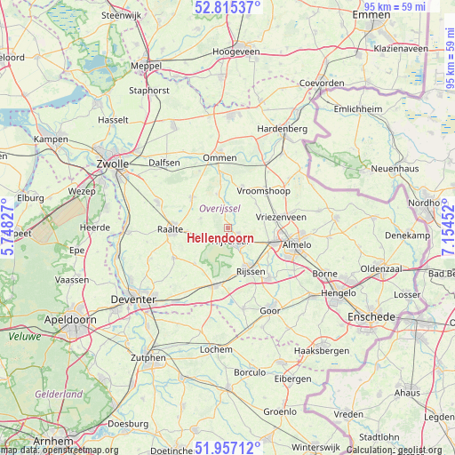
Hellendoorn GPS coordinates[2]
52° 23' 17.988" North, 6° 27' 5.004" East
| Map corner | latitude | longitude |
|---|---|---|
| Upper-left | 52.81537°, | 5.74827° |
| Center: | 52.38833°, | 6.45139° |
| Lower-right: | 51.95712°, | 7.15452° |
| Map W x H: | 95.4×95.4 km | = 59.3×59.3mi |
| max Lat: | 53.48025° ⇑31% North |
| Hellendoorn: | 52.38833° |
| min Lat: | ⇓69% South 50.76917° |
| min Long | Hellendoorn | max Long |
| 3.38611° | 6.45139° | 7.16528° |
| W 88%⇐ | ⇒12% E |
Elevation
Elevation of Hellendoorn is 14 m = 46 ft, and this is 1 m = 3 ft below average elevation for this country.
| Max E: |
203 m = 666 ft | 31% |
| Avg. | 15 m = 49 ft | |
| Hellendoorn | 14 m = 46 ft | |
Min E: |
-6 m = -20 ft | 69% |
See also: Netherlands elevation on elevation.city.
Geographical zone
Hellendoorn is located in North temperate zone (between Tropic of Cancer and the Arctic Circle). Distance of this North polar circle is 1576.1 km =979.3 mi to North.| Distance of | km | miles | from Hellendoorn |
|---|---|---|---|
| North Pole | 4182 | 2598.6 | to North |
| Arctic Circle | 1576.1 | 979.3 | to North |
| Tropic Cancer | 3219.1 | 2000.3 | to South |
| Equator | 5825 | 3619.5 | to South |


Nearby cities:
15 places around Hellendoorn: (largest is in red/bold)
• Almelo
14.8 km =9.2 mi,  103°
103°
• Daarle
7.8 km =4.8 mi,  48°
48°
• Den Ham
9.1 km =5.7 mi,  19°
19°
• Elsen
14.4 km =8.9 mi,  155°
155°
• Haarle
5.8 km =3.6 mi,  236°
236°
• Hulsen
1.8 km =1.1 mi,  124°
124°
• Magele
10.1 km =6.3 mi,  27°
27°
• Marle
4.4 km =2.7 mi, 26°
• Nieuwoord
11 km =6.8 mi,  37°
37°
• Ommen
14.9 km =9.3 mi,  351°
351°
• Raalte
12 km =7.5 mi,  268°
268°
• Vriezenveen
11.8 km =7.3 mi,  79°
79°
• Vroomshoop
11.2 km =7 mi, 43°
• Westerhaar-Vriezenveensewijk
13.9 km =8.6 mi,  57°
57°
• Wierden
10.1 km =6.3 mi,  108°
108°
Sources, notices
• [Note1] Compared only with cities in Netherlands existing in our database
• [Src1] Map data: © OpenStreetMap contributors (CC-BY-SA)
• [Src2] Other city data from geonames.org with taken over terms of usage.
• [Src3] Geographical zone / Annual Mean Temperature by Robert A. Rohde @ Wikipedia
