Cruquius geodata
Cruquius (North Holland) is a populated place; located in Netherlands in Europe/Amsterdam (GMT+2) time zone. With population of 695 people, there are 1632 cities with bigger population in this country. Compared to other cities in Netherlands, 67.6% of cities are located further ↓South; 85.4% of cities are located further →East and 98.2% of cities have higher elevation than Cruquius. Note1


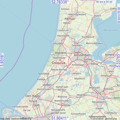
Cruquius GPS coordinates[2]
52° 20' 8.988" North, 4° 38' 4.992" East
| Map corner | latitude | longitude |
|---|---|---|
| Upper-left | 52.76338°, | 3.9316° |
| Center: | 52.33583°, | 4.63472° |
| Lower-right: | 51.90411°, | 5.33785° |
| Map W x H: | 95.5×95.5 km | = 59.3×59.3mi |
| max Lat: | 53.48025° ⇑32.4% North |
| Cruquius: | 52.33583° |
| min Lat: | ⇓67.6% South 50.76917° |
| min Long | Cruquius | max Long |
| 3.38611° | 4.63472° | 7.16528° |
| W 14.6%⇐ | ⇒85.4% E |
Elevation
Elevation of Cruquius is -2 m = -7 ft, and this is 17 m = 56 ft below average elevation for this country.
| Max E: |
203 m = 666 ft | 98.2% |
| Avg. | 15 m = 49 ft | |
| Cruquius | -2 m = -7 ft | |
Min E: |
-6 m = -20 ft | 1.8% |
See also: Netherlands elevation on elevation.city.
Geographical zone
Cruquius is located in North temperate zone (between Tropic of Cancer and the Arctic Circle). Distance of this North polar circle is 1582 km =983 mi to North.| Distance of | km | miles | from Cruquius |
|---|---|---|---|
| North Pole | 4187.9 | 2602.2 | to North |
| Arctic Circle | 1582 | 983 | to North |
| Tropic Cancer | 3213.3 | 1996.7 | to South |
| Equator | 5819.2 | 3615.9 | to South |


Nearby cities:
15 places around Cruquius: (largest is in red/bold)
• Beinsdorp
6.1 km =3.8 mi,  205°
205°
• Bennebroek
3 km =1.9 mi,  235°
235°
• Bloemendaal
7.5 km =4.7 mi,  353°
353°
• De Glip
1.7 km =1.1 mi,  250°
250°
• Haarlem
5 km =3.1 mi,  1°
1°
• Heemstede
1.8 km =1.1 mi,  333°
333°
• Hillegom
6.1 km =3.8 mi, 214°
• Hoofddorp
5.2 km =3.2 mi,  135°
135°
• Lijnden
8.5 km =5.3 mi,  77°
77°
• Overveen
6.4 km =4 mi, 347°
• Vijfhuizen
3.4 km =2.1 mi,  60°
60°
• Vogelenzang
4.3 km =2.7 mi, 244°
• Weerestein
4.7 km =2.9 mi,  221°
221°
• Zandvoort
7.9 km =4.9 mi,  299°
299°
• Zwaanshoek
2.9 km =1.8 mi, 205°
Sources, notices
• [Note1] Compared only with cities in Netherlands existing in our database
• [Src1] Map data: © OpenStreetMap contributors (CC-BY-SA)
• [Src2] Other city data from geonames.org with taken over terms of usage.
• [Src3] Geographical zone / Annual Mean Temperature by Robert A. Rohde @ Wikipedia
