Haarlem geodata
Haarlem (North Holland) is a seat of a first-order administrative division; located in Netherlands in Europe/Amsterdam (GMT+2) time zone. With population of 147,590 people, there are 11 cities with bigger population in this country. Compared to other cities in Netherlands, 68.7% of cities are located further ↓South; 85.2% of cities are located further →East and 59.4% of cities have lower elevation than Haarlem. Note1


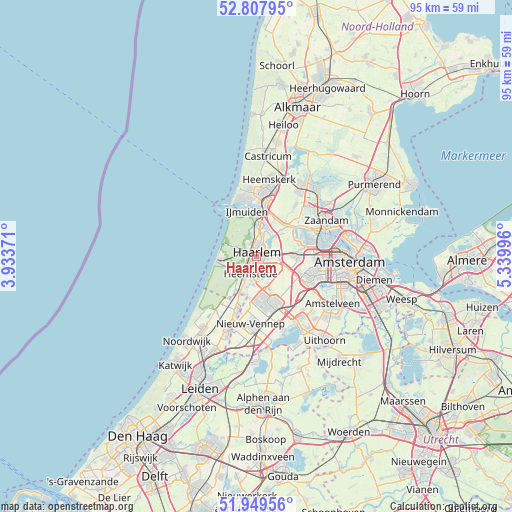
Haarlem GPS coordinates[2]
52° 22' 51.024" North, 4° 38' 12.588" East
| Map corner | latitude | longitude |
|---|---|---|
| Upper-left | 52.80795°, | 3.93371° |
| Center: | 52.38084°, | 4.63683° |
| Lower-right: | 51.94956°, | 5.33996° |
| Map W x H: | 95.4×95.4 km | = 59.3×59.3mi |
| max Lat: | 53.48025° ⇑31.3% North |
| Haarlem: | 52.38084° |
| min Lat: | ⇓68.7% South 50.76917° |
| min Long | Haarlem | max Long |
| 3.38611° | 4.63683° | 7.16528° |
| W 14.8%⇐ | ⇒85.2% E |
Elevation
Elevation of Haarlem is 10 m = 33 ft, and this is 5 m = 16 ft below average elevation for this country.
| Max E: |
203 m = 666 ft | 40.6% |
| Avg. | 15 m = 49 ft | |
| Haarlem | 10 m = 33 ft | |
Min E: |
-6 m = -20 ft | 59.4% |
See also: Haarlem elevation on elevation.city.
Geographical zone
Haarlem is located in North temperate zone (between Tropic of Cancer and the Arctic Circle). Distance of this North polar circle is 1577 km =979.9 mi to North.| Distance of | km | miles | from Haarlem |
|---|---|---|---|
| North Pole | 4182.9 | 2599.1 | to North |
| Arctic Circle | 1577 | 979.9 | to North |
| Tropic Cancer | 3218.3 | 1999.8 | to South |
| Equator | 5824.2 | 3619 | to South |


Nearby cities:
15 places around Haarlem: (largest is in red/bold)
• Bennebroek
7.2 km =4.5 mi,  201°
201°
• Bloemendaal
2.6 km =1.6 mi,  337°
337°
• Cruquius
5 km =3.1 mi,  181°
181°
• De Glip
5.8 km =3.6 mi, 197°
• Halfweg
8 km =5 mi,  88°
88°
• Heemstede
3.6 km =2.2 mi, 195°
• Hofgeest
7.1 km =4.4 mi,  11°
11°
• Lijnden
8.7 km =5.4 mi,  111°
111°
• Overveen
2 km =1.2 mi,  307°
307°
• Velsen-Zuid
8.8 km =5.5 mi, 5°
• Vijfhuizen
4.3 km =2.7 mi,  140°
140°
• Vogelenzang
7.9 km =4.9 mi,  210°
210°
• Weerestein
9.2 km =5.7 mi, 200°
• Zandvoort
7.1 km =4.4 mi,  261°
261°
• Zwaanshoek
7.7 km =4.8 mi,  190°
190°
Sources, notices
• [Note1] Compared only with cities in Netherlands existing in our database
• [Src1] Map data: © OpenStreetMap contributors (CC-BY-SA)
• [Src2] Other city data from geonames.org with taken over terms of usage.
• [Src3] Geographical zone / Annual Mean Temperature by Robert A. Rohde @ Wikipedia
