Vlokhoven geodata
Vlokhoven (North Brabant) is a populated place; located in Netherlands in Europe/Amsterdam (GMT+2) time zone. With population of 3,570 people, there are 660 cities with bigger population in this country. Compared to other cities in Netherlands, 83% of cities are located further ↑North; 57.5% of cities are located further →East and 73.5% of cities have lower elevation than Vlokhoven. Note1


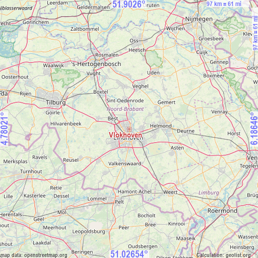
Vlokhoven GPS coordinates[2]
51° 28' 0.012" North, 5° 28' 59.988" East
| Map corner | latitude | longitude |
|---|---|---|
| Upper-left | 51.9026°, | 4.78021° |
| Center: | 51.46667°, | 5.48333° |
| Lower-right: | 51.02654°, | 6.18646° |
| Map W x H: | 97.4×97.4 km | = 60.5×60.5mi |
| max Lat: | 53.48025° ⇑83% North |
| Vlokhoven: | 51.46667° |
| min Lat: | ⇓17% South 50.76917° |
| min Long | Vlokhoven | max Long |
| 3.38611° | 5.48333° | 7.16528° |
| W 42.5%⇐ | ⇒57.5% E |
Elevation
Elevation of Vlokhoven is 17 m = 56 ft, and this is 2 m = 7 ft above average elevation for this country.
| Max E: |
203 m = 666 ft | 26.5% |
| Vlokhoven | 17 m 56 ft | |
| Avg. | 15 m = 49 ft | |
Min E: |
-6 m = -20 ft | 73.5% |
See also: Netherlands elevation on elevation.city.
Geographical zone
Vlokhoven is located in North temperate zone (between Tropic of Cancer and the Arctic Circle). Distance of this North polar circle is 1678.6 km =1043 mi to North.| Distance of | km | miles | from Vlokhoven |
|---|---|---|---|
| North Pole | 4284.5 | 2662.3 | to North |
| Arctic Circle | 1678.6 | 1043 | to North |
| Tropic Cancer | 3116.6 | 1936.6 | to South |
| Equator | 5722.6 | 3555.9 | to South |


Nearby cities:
15 places around Vlokhoven: (largest is in red/bold)
• 't Hofke
3.1 km =1.9 mi,  127°
127°
• De Doornakkers
3.6 km =2.2 mi,  150°
150°
• Eckart
1.1 km =0.7 mi,  46°
46°
• Eeneind
4.7 km =2.9 mi,  110°
110°
• Eindhoven
2.9 km =1.8 mi,  187°
187°
• Heesterakker
2.4 km =1.5 mi,  23°
23°
• Jagershoef
1.3 km =0.8 mi,  303°
303°
• Lakerlopen
3.4 km =2.1 mi,  158°
158°
• Lievendaal
4.4 km =2.7 mi,  231°
231°
• Muschberg en Geestenberg
3.8 km =2.4 mi, 132°
• Nederwetten
3.9 km =2.4 mi, 45°
• Tongelre
3.2 km =2 mi, 128°
• Vaartbroek
1.8 km =1.1 mi,  35°
35°
• Villapark
2.9 km =1.8 mi,  165°
165°
• Woenselse Heide
2.2 km =1.4 mi,  328°
328°
Sources, notices
• [Note1] Compared only with cities in Netherlands existing in our database
• [Src1] Map data: © OpenStreetMap contributors (CC-BY-SA)
• [Src2] Other city data from geonames.org with taken over terms of usage.
• [Src3] Geographical zone / Annual Mean Temperature by Robert A. Rohde @ Wikipedia
