Lievendaal geodata
Lievendaal (North Brabant) is a section of populated place; located in Netherlands in Europe/Amsterdam (GMT+2) time zone. With population of 3,175 people, there are 727 cities with bigger population in this country. Compared to other cities in Netherlands, 84.3% of cities are located further ↑North; 59.2% of cities are located further →East and 77.1% of cities have lower elevation than Lievendaal. Note1


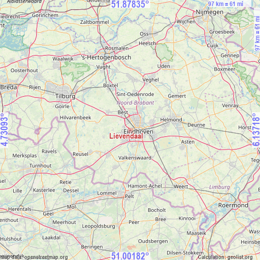
Lievendaal GPS coordinates[2]
51° 26' 31.884" North, 5° 26' 2.58" East
| Map corner | latitude | longitude |
|---|---|---|
| Upper-left | 51.87835°, | 4.73093° |
| Center: | 51.44219°, | 5.43405° |
| Lower-right: | 51.00182°, | 6.13718° |
| Map W x H: | 97.5×97.5 km | = 60.6×60.6mi |
| max Lat: | 53.48025° ⇑84.3% North |
| Lievendaal: | 51.44219° |
| min Lat: | ⇓15.7% South 50.76917° |
| min Long | Lievendaal | max Long |
| 3.38611° | 5.43405° | 7.16528° |
| W 40.8%⇐ | ⇒59.2% E |
Elevation
Elevation of Lievendaal is 19 m = 62 ft, and this is 4 m = 13 ft above average elevation for this country.
| Max E: |
203 m = 666 ft | 22.9% |
| Lievendaal | 19 m 62 ft | |
| Avg. | 15 m = 49 ft | |
Min E: |
-6 m = -20 ft | 77.1% |
See also: Netherlands elevation on elevation.city.
Geographical zone
Lievendaal is located in North temperate zone (between Tropic of Cancer and the Arctic Circle). Distance of this North polar circle is 1681.3 km =1044.7 mi to North.| Distance of | km | miles | from Lievendaal |
|---|---|---|---|
| North Pole | 4287.2 | 2663.9 | to North |
| Arctic Circle | 1681.3 | 1044.7 | to North |
| Tropic Cancer | 3113.9 | 1934.9 | to South |
| Equator | 5719.8 | 3554.1 | to South |


Nearby cities:
15 places around Lievendaal: (largest is in red/bold)
• Blaarthem
2.5 km =1.6 mi,  139°
139°
• Eindhoven
3 km =1.9 mi,  92°
92°
• Grasrijk
1.3 km =0.8 mi,  255°
255°
• Jagershoef
4.2 km =2.6 mi,  33°
33°
• Lakerlopen
4.7 km =2.9 mi,  95°
95°
• Meerhoven
1.6 km =1 mi,  271°
271°
• Meerveldhoven
3.1 km =1.9 mi,  203°
203°
• Oerle
4.8 km =3 mi,  243°
243°
• Ooievaarsnest
2.8 km =1.7 mi,  181°
181°
• Veldhoven
3.4 km =2.1 mi,  219°
219°
• Villapark
4.1 km =2.5 mi, 91°
• Vlokhoven
4.4 km =2.7 mi,  51°
51°
• Woenselse Heide
5.1 km =3.2 mi, 26°
• Zeelst
2.4 km =1.5 mi,  212°
212°
• Zonderwijk
4.4 km =2.7 mi, 219°
Sources, notices
• [Note1] Compared only with cities in Netherlands existing in our database
• [Src1] Map data: © OpenStreetMap contributors (CC-BY-SA)
• [Src2] Other city data from geonames.org with taken over terms of usage.
• [Src3] Geographical zone / Annual Mean Temperature by Robert A. Rohde @ Wikipedia
