Uddel geodata
Uddel (Gelderland) is a populated place; located in Netherlands in Europe/Amsterdam (GMT+2) time zone. With population of 1,865 people, there are 1006 cities with bigger population in this country. Compared to other cities in Netherlands, 64.7% of cities are located further ↓South; 56.4% of cities are located further ←West and 89.2% of cities have lower elevation than Uddel. Note1


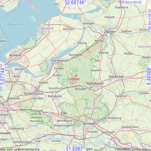
Uddel GPS coordinates[2]
52° 15' 33.012" North, 5° 46' 50.016" East
| Map corner | latitude | longitude |
|---|---|---|
| Upper-left | 52.68746°, | 5.07744° |
| Center: | 52.25917°, | 5.78056° |
| Lower-right: | 51.8267°, | 6.48369° |
| Map W x H: | 95.7×95.7 km | = 59.5×59.5mi |
| max Lat: | 53.48025° ⇑35.3% North |
| Uddel: | 52.25917° |
| min Lat: | ⇓64.7% South 50.76917° |
| min Long | Uddel | max Long |
| 3.38611° | 5.78056° | 7.16528° |
| W 56.4%⇐ | ⇒43.6% E |
Elevation
Elevation of Uddel is 32 m = 105 ft, and this is 17 m = 56 ft above average elevation for this country.
| Max E: |
203 m = 666 ft | 10.8% |
| Uddel | 32 m 105 ft | |
| Avg. | 15 m = 49 ft | |
Min E: |
-6 m = -20 ft | 89.2% |
See also: Netherlands elevation on elevation.city.
Geographical zone
Uddel is located in North temperate zone (between Tropic of Cancer and the Arctic Circle). Distance of this North polar circle is 1590.5 km =988.3 mi to North.| Distance of | km | miles | from Uddel |
|---|---|---|---|
| North Pole | 4196.4 | 2607.5 | to North |
| Arctic Circle | 1590.5 | 988.3 | to North |
| Tropic Cancer | 3204.8 | 1991.4 | to South |
| Equator | 5810.7 | 3610.6 | to South |


Nearby cities:
15 places around Uddel: (largest is in red/bold)
• Berg en Bos
11.3 km =7 mi,  112°
112°
• Brinkhorst
12.7 km =7.9 mi, 113°
• Driehuizen
12.5 km =7.8 mi,  116°
116°
• Elspeet
3.7 km =2.3 mi,  8°
8°
• Ermelo
11.6 km =7.2 mi,  292°
292°
• Garderen
5.5 km =3.4 mi,  235°
235°
• Het Loo
12.1 km =7.5 mi,  103°
103°
• Hommelbrink
12.7 km =7.9 mi, 100°
• Hulshorst
12 km =7.5 mi,  344°
344°
• Orden
12.3 km =7.6 mi, 121°
• Putten
11.8 km =7.3 mi,  270°
270°
• Spainkbos
12.1 km =7.5 mi, 109°
• Sprengenbos
11.8 km =7.3 mi, 112°
• Sprengenweg-Noord
12.4 km =7.7 mi, 111°
• Stroe
10.2 km =6.3 mi,  216°
216°
Sources, notices
• [Note1] Compared only with cities in Netherlands existing in our database
• [Src1] Map data: © OpenStreetMap contributors (CC-BY-SA)
• [Src2] Other city data from geonames.org with taken over terms of usage.
• [Src3] Geographical zone / Annual Mean Temperature by Robert A. Rohde @ Wikipedia
