Hulshorst geodata
Hulshorst (Gelderland) is a populated place; located in Netherlands in Europe/Amsterdam (GMT+2) time zone. With population of 775 people, there are 1546 cities with bigger population in this country. Compared to other cities in Netherlands, 68.4% of cities are located further ↓South; 53.6% of cities are located further ←West and 57.3% of cities have lower elevation than Hulshorst. Note1


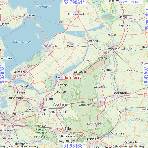
Hulshorst GPS coordinates[2]
52° 21' 47.988" North, 5° 43' 54.984" East
| Map corner | latitude | longitude |
|---|---|---|
| Upper-left | 52.79061°, | 5.02882° |
| Center: | 52.36333°, | 5.73194° |
| Lower-right: | 51.93188°, | 6.43507° |
| Map W x H: | 95.5×95.5 km | = 59.3×59.3mi |
| max Lat: | 53.48025° ⇑31.6% North |
| Hulshorst: | 52.36333° |
| min Lat: | ⇓68.4% South 50.76917° |
| min Long | Hulshorst | max Long |
| 3.38611° | 5.73194° | 7.16528° |
| W 53.6%⇐ | ⇒46.4% E |
Elevation
Elevation of Hulshorst is 9 m = 30 ft, and this is 6 m = 20 ft below average elevation for this country.
| Max E: |
203 m = 666 ft | 42.7% |
| Avg. | 15 m = 49 ft | |
| Hulshorst | 9 m = 30 ft | |
Min E: |
-6 m = -20 ft | 57.3% |
See also: Netherlands elevation on elevation.city.
Geographical zone
Hulshorst is located in North temperate zone (between Tropic of Cancer and the Arctic Circle). Distance of this North polar circle is 1578.9 km =981.1 mi to North.| Distance of | km | miles | from Hulshorst |
|---|---|---|---|
| North Pole | 4184.8 | 2600.3 | to North |
| Arctic Circle | 1578.9 | 981.1 | to North |
| Tropic Cancer | 3216.3 | 1998.5 | to South |
| Equator | 5822.3 | 3617.8 | to South |


Nearby cities:
15 places around Hulshorst: (largest is in red/bold)
• Biddinghuizen
10.5 km =6.5 mi,  345°
345°
• Doornspijk
8.5 km =5.3 mi,  43°
43°
• Elburg
12 km =7.5 mi, 38°
• Elspeet
8.9 km =5.5 mi,  154°
154°
• Ermelo
10.4 km =6.5 mi,  225°
225°
• Garderen
14.8 km =9.2 mi,  184°
184°
• Harderwijk
7.9 km =4.9 mi,  252°
252°
• Hoge Enk
10.5 km =6.5 mi,  45°
45°
• Nunspeet
4.1 km =2.5 mi,  64°
64°
• Oldebroek
14.6 km =9.1 mi, 51°
• Oostendorp
12.5 km =7.8 mi, 41°
• Oosterwolde
15.7 km =9.8 mi, 43°
• Putten
14.4 km =8.9 mi,  216°
216°
• Uddel
12 km =7.5 mi,  164°
164°
• Zeewolde
13.4 km =8.3 mi, 253°
Sources, notices
• [Note1] Compared only with cities in Netherlands existing in our database
• [Src1] Map data: © OpenStreetMap contributors (CC-BY-SA)
• [Src2] Other city data from geonames.org with taken over terms of usage.
• [Src3] Geographical zone / Annual Mean Temperature by Robert A. Rohde @ Wikipedia
