Assen geodata
Assen (Drenthe) is a seat of a first-order administrative division; located in Netherlands in Europe/Amsterdam (GMT+2) time zone. With population of 62,237 people, there are 50 cities with bigger population in this country. Compared to other cities in Netherlands, 85.5% of cities are located further ↓South; 90.1% of cities are located further ←West and 64.6% of cities have lower elevation than Assen. Note1


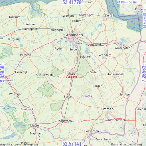
Assen GPS coordinates[2]
52° 59' 48.012" North, 6° 33' 45" East
| Map corner | latitude | longitude |
|---|---|---|
| Upper-left | 53.41778°, | 5.85938° |
| Center: | 52.99667°, | 6.5625° |
| Lower-right: | 52.57141°, | 7.26563° |
| Map W x H: | 94.1×94.1 km | = 58.5×58.5mi |
| max Lat: | 53.48025° ⇑14.5% North |
| Assen: | 52.99667° |
| min Lat: | ⇓85.5% South 50.76917° |
| min Long | Assen | max Long |
| 3.38611° | 6.5625° | 7.16528° |
| W 90.1%⇐ | ⇒9.9% E |
Elevation
Elevation of Assen is 12 m = 39 ft, and this is 3 m = 10 ft below average elevation for this country.
| Max E: |
203 m = 666 ft | 35.4% |
| Avg. | 15 m = 49 ft | |
| Assen | 12 m = 39 ft | |
Min E: |
-6 m = -20 ft | 64.6% |
See also: Assen elevation on elevation.city.
Geographical zone
Assen is located in North temperate zone (between Tropic of Cancer and the Arctic Circle). Distance of this North polar circle is 1508.5 km =937.3 mi to North.| Distance of | km | miles | from Assen |
|---|---|---|---|
| North Pole | 4114.4 | 2556.6 | to North |
| Arctic Circle | 1508.5 | 937.3 | to North |
| Tropic Cancer | 3286.8 | 2042.3 | to South |
| Equator | 5892.7 | 3661.6 | to South |


Nearby cities:
15 places around Assen: (largest is in red/bold)
• Annen
12.5 km =7.8 mi,  57°
57°
• Eext
11.8 km =7.3 mi,  78°
78°
• Grolloo
10.1 km =6.3 mi,  133°
133°
• Hijken
12.1 km =7.5 mi,  201°
201°
• Hooghalen
8.6 km =5.3 mi,  190°
190°
• Marsdijk
2.8 km =1.7 mi,  33°
33°
• Norg
10.4 km =6.5 mi,  318°
318°
• Peelo
2.3 km =1.4 mi,  359°
359°
• Rolde
5.9 km =3.7 mi,  103°
103°
• Schipborg
11.3 km =7 mi,  39°
39°
• Tynaarlo
9.7 km =6 mi,  21°
21°
• Veenhuizen
11.8 km =7.3 mi,  289°
289°
• Vries
8.7 km =5.4 mi,  6°
6°
• Westlaren
11.9 km =7.4 mi, 34°
• Zeyen
5.8 km =3.6 mi,  348°
348°
Sources, notices
• [Note1] Compared only with cities in Netherlands existing in our database
• [Src1] Map data: © OpenStreetMap contributors (CC-BY-SA)
• [Src2] Other city data from geonames.org with taken over terms of usage.
• [Src3] Geographical zone / Annual Mean Temperature by Robert A. Rohde @ Wikipedia
