Termaar geodata
Termaar (Limburg) is a populated place; located in Netherlands in Europe/Amsterdam (GMT+2) time zone. With population of 730 people, there are 1585 cities with bigger population in this country. Compared to other cities in Netherlands, 97.3% of cities are located further ↑North; 63.5% of cities are located further ←West and 98.1% of cities have lower elevation than Termaar. Note1


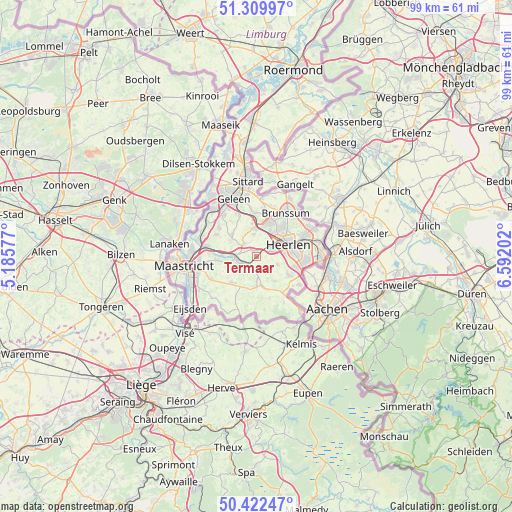
Termaar GPS coordinates[2]
50° 52' 5.988" North, 5° 53' 20.004" East
| Map corner | latitude | longitude |
|---|---|---|
| Upper-left | 51.30997°, | 5.18577° |
| Center: | 50.86833°, | 5.88889° |
| Lower-right: | 50.42247°, | 6.59202° |
| Map W x H: | 98.7×98.7 km | = 61.3×61.3mi |
| max Lat: | 53.48025° ⇑97.3% North |
| Termaar: | 50.86833° |
| min Lat: | ⇓2.7% South 50.76917° |
| min Long | Termaar | max Long |
| 3.38611° | 5.88889° | 7.16528° |
| W 63.5%⇐ | ⇒36.5% E |
Elevation
Elevation of Termaar is 130 m = 427 ft, and this is 115 m = 377 ft above average elevation for this country.
| Max E: |
203 m = 666 ft | 1.9% |
| Termaar | 130 m 427 ft | |
| Avg. | 15 m = 49 ft | |
Min E: |
-6 m = -20 ft | 98.1% |
See also: Netherlands elevation on elevation.city.
Geographical zone
Termaar is located in North temperate zone (between Tropic of Cancer and the Arctic Circle). Distance of this North polar circle is 1745.1 km =1084.4 mi to North.| Distance of | km | miles | from Termaar |
|---|---|---|---|
| North Pole | 4351 | 2703.6 | to North |
| Arctic Circle | 1745.1 | 1084.4 | to North |
| Tropic Cancer | 3050.1 | 1895.2 | to South |
| Equator | 5656 | 3514.5 | to South |


Nearby cities:
15 places around Termaar: (largest is in red/bold)
• Arensgenhout
4.1 km =2.5 mi,  303°
303°
• Broekhem
4.8 km =3 mi,  273°
273°
• Hulsberg
3.3 km =2.1 mi,  314°
314°
• Husken
5.6 km =3.5 mi,  57°
57°
• Klimmen
1 km =0.6 mi,  324°
324°
• Kunrade
3.1 km =1.9 mi,  70°
70°
• Nuth
5.5 km =3.4 mi,  357°
357°
• Ransdaal
0.4 km =0.2 mi,  152°
152°
• Schin op Geul
2.1 km =1.3 mi,  220°
220°
• Sibbe
5.1 km =3.2 mi,  238°
238°
• Ubachsberg
4.5 km =2.8 mi,  111°
111°
• Valkenburg
4 km =2.5 mi, 265°
• Voerendaal
3.3 km =2.1 mi, 59°
• Wijlre
3.9 km =2.4 mi,  172°
172°
• Wijnandsrade
4.2 km =2.6 mi,  354°
354°
Sources, notices
• [Note1] Compared only with cities in Netherlands existing in our database
• [Src1] Map data: © OpenStreetMap contributors (CC-BY-SA)
• [Src2] Other city data from geonames.org with taken over terms of usage.
• [Src3] Geographical zone / Annual Mean Temperature by Robert A. Rohde @ Wikipedia
