Gasselternijveenschemond geodata
Gasselternijveenschemond (Drenthe) is a populated place; located in Netherlands in Europe/Amsterdam (GMT+2) time zone. With population of 625 people, there are 1695 cities with bigger population in this country. Compared to other cities in Netherlands, 85.4% of cities are located further ↓South; 97.1% of cities are located further ←West and 58.8% of cities have higher elevation than Gasselternijveenschemond. Note1
Current local time in Gasselternijveenschemond:
06:39 AM, ThursdayDifference from your time zone: hours


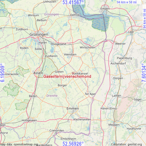
Gasselternijveenschemond GPS coordinates[2]
52° 59' 40.344" North, 6° 53' 53.556" East
| Map corner | latitude | longitude |
|---|---|---|
| Upper-left | 53.41567°, | 6.19509° |
| Center: | 52.99454°, | 6.89821° |
| Lower-right: | 52.56926°, | 7.60134° |
| Map W x H: | 94.1×94.1 km | = 58.5×58.5mi |
| max Lat: | 53.48025° ⇑14.6% North |
| Gasselternijveenschemond: | 52.99454° |
| min Lat: | ⇓85.4% South 50.76917° |
| min Long | Gasselternijvee | max Long |
| 3.38611° | 6.89821° | 7.16528° |
| W 97.1%⇐ | ⇒2.9% E |
Elevation
Elevation of Gasselternijveenschemond is 4 m = 13 ft, and this is 11 m = 36 ft below average elevation for this country.
| Max E: |
203 m = 666 ft | 58.8% |
| Avg. | 15 m = 49 ft | |
| Gasselternijveenschemond | 4 m = 13 ft | |
Min E: |
-6 m = -20 ft | 41.2% |
See also: Netherlands elevation on elevation.city.
Geographical zone
Gasselternijveenschemond is located in North temperate zone (between Tropic of Cancer and the Arctic Circle). Distance of this North polar circle is 1508.7 km =937.5 mi to North.| Distance of | km | miles | from Gasselternijveenschemond |
|---|---|---|---|
| North Pole | 4114.6 | 2556.7 | to North |
| Arctic Circle | 1508.7 | 937.5 | to North |
| Tropic Cancer | 3286.5 | 2042.1 | to South |
| Equator | 5892.4 | 3661.4 | to South |


Nearby cities:
15 places around Gasselternijveenschemond: (largest is in red/bold)
• Alteveer
9 km =5.6 mi,  45°
45°
• Buinen
8.2 km =5.1 mi,  210°
210°
• Ceresdorp
5.9 km =3.7 mi,  122°
122°
• Drouwenermond
1.9 km =1.2 mi,  164°
164°
• Gasselte
7.4 km =4.6 mi,  249°
249°
• Gasselternijveen
3.1 km =1.9 mi,  257°
257°
• Gieten
9.1 km =5.7 mi,  277°
277°
• Gieterveen
5.5 km =3.4 mi,  312°
312°
• Mussel
10.4 km =6.5 mi, 115°
• Nieuw-Buinen
5 km =3.1 mi,  135°
135°
• Nieuwe Pekela
10.4 km =6.5 mi,  25°
25°
• Ommelanderwijk
10.5 km =6.5 mi,  2°
2°
• Stadskanaal
3.5 km =2.2 mi,  99°
99°
• Tweede Exloërmond
9.8 km =6.1 mi,  166°
166°
• Wildervank
9.9 km =6.2 mi,  346°
346°
Sources, notices
• [Note1] Compared only with cities in Netherlands existing in our database
• [Src1] Map data: © OpenStreetMap contributors (CC-BY-SA)
• [Src2] Other city data from geonames.org with taken over terms of usage.
• [Src3] Geographical zone / Annual Mean Temperature by Robert A. Rohde @ Wikipedia
