Ootmarsum geodata
Ootmarsum (Overijssel) is a populated place; located in Netherlands in Europe/Amsterdam (GMT+2) time zone. With population of 4,450 people, there are 541 cities with bigger population in this country. Compared to other cities in Netherlands, 69.3% of cities are located further ↓South; 97.2% of cities are located further ←West and 91.2% of cities have lower elevation than Ootmarsum. Note1


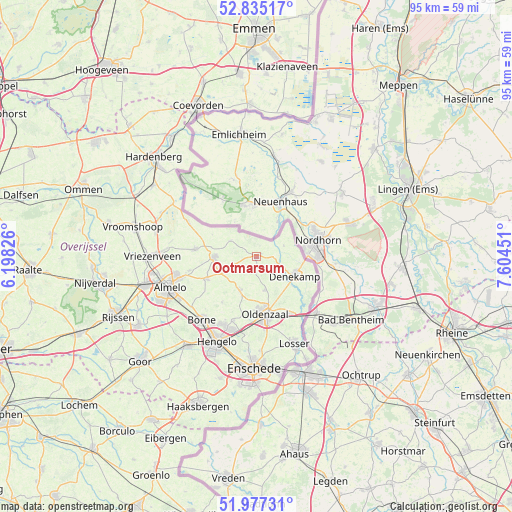
Ootmarsum GPS coordinates[2]
52° 24' 29.988" North, 6° 54' 5.004" East
| Map corner | latitude | longitude |
|---|---|---|
| Upper-left | 52.83517°, | 6.19826° |
| Center: | 52.40833°, | 6.90139° |
| Lower-right: | 51.97731°, | 7.60451° |
| Map W x H: | 95.4×95.4 km | = 59.3×59.3mi |
| max Lat: | 53.48025° ⇑30.7% North |
| Ootmarsum: | 52.40833° |
| min Lat: | ⇓69.3% South 50.76917° |
| min Long | Ootmarsum | max Long |
| 3.38611° | 6.90139° | 7.16528° |
| W 97.2%⇐ | ⇒2.8% E |
Elevation
Elevation of Ootmarsum is 36 m = 118 ft, and this is 21 m = 69 ft above average elevation for this country.
| Max E: |
203 m = 666 ft | 8.8% |
| Ootmarsum | 36 m 118 ft | |
| Avg. | 15 m = 49 ft | |
Min E: |
-6 m = -20 ft | 91.2% |
See also: Netherlands elevation on elevation.city.
Geographical zone
Ootmarsum is located in North temperate zone (between Tropic of Cancer and the Arctic Circle). Distance of this North polar circle is 1573.9 km =978 mi to North.| Distance of | km | miles | from Ootmarsum |
|---|---|---|---|
| North Pole | 4179.8 | 2597.2 | to North |
| Arctic Circle | 1573.9 | 978 | to North |
| Tropic Cancer | 3221.3 | 2001.6 | to South |
| Equator | 5827.3 | 3620.9 | to South |


Nearby cities:
15 places around Ootmarsum: (largest is in red/bold)
• Almelo
17.2 km =10.7 mi,  250°
250°
• Borne
15.8 km =9.8 mi,  221°
221°
• Hengelo
17.5 km =10.9 mi,  204°
204°
• Klein Driene
16.5 km =10.3 mi, 200°
• Losser
17.8 km =11.1 mi,  156°
156°
• Nijrees
18.1 km =11.2 mi,  243°
243°
• Oldenzaal
10.7 km =6.6 mi,  169°
169°
• Rossum
6.5 km =4 mi, 167°
• Saasveld
10.7 km =6.6 mi, 216°
• Tilligte
3.4 km =2.1 mi,  94°
94°
• Tubbergen
7.9 km =4.9 mi,  269°
269°
• Weerselo
7 km =4.3 mi,  205°
205°
• Woolde
18 km =11.2 mi, 212°
• Zenderen
15.3 km =9.5 mi,  232°
232°
• Zuid-Berghuizen
12.1 km =7.5 mi, 169°
Sources, notices
• [Note1] Compared only with cities in Netherlands existing in our database
• [Src1] Map data: © OpenStreetMap contributors (CC-BY-SA)
• [Src2] Other city data from geonames.org with taken over terms of usage.
• [Src3] Geographical zone / Annual Mean Temperature by Robert A. Rohde @ Wikipedia
