Rossum geodata
Rossum (Overijssel) is a populated place; located in Netherlands in Europe/Amsterdam (GMT+2) time zone. With population of 1,355 people, there are 1208 cities with bigger population in this country. Compared to other cities in Netherlands, 68% of cities are located further ↓South; 97.6% of cities are located further ←West and 86.2% of cities have lower elevation than Rossum. Note1


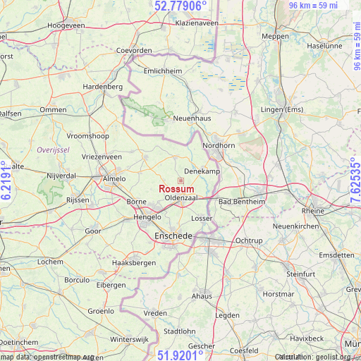
Rossum GPS coordinates[2]
52° 21' 6.012" North, 6° 55' 19.992" East
| Map corner | latitude | longitude |
|---|---|---|
| Upper-left | 52.77906°, | 6.2191° |
| Center: | 52.35167°, | 6.92222° |
| Lower-right: | 51.9201°, | 7.62535° |
| Map W x H: | 95.5×95.5 km | = 59.3×59.3mi |
| max Lat: | 53.48025° ⇑32% North |
| Rossum: | 52.35167° |
| min Lat: | ⇓68% South 50.76917° |
| min Long | Rossum | max Long |
| 3.38611° | 6.92222° | 7.16528° |
| W 97.6%⇐ | ⇒2.4% E |
Elevation
Elevation of Rossum is 28 m = 92 ft, and this is 13 m = 43 ft above average elevation for this country.
| Max E: |
203 m = 666 ft | 13.8% |
| Rossum | 28 m 92 ft | |
| Avg. | 15 m = 49 ft | |
Min E: |
-6 m = -20 ft | 86.2% |
See also: Netherlands elevation on elevation.city.
Geographical zone
Rossum is located in North temperate zone (between Tropic of Cancer and the Arctic Circle). Distance of this North polar circle is 1580.2 km =981.9 mi to North.| Distance of | km | miles | from Rossum |
|---|---|---|---|
| North Pole | 4186.1 | 2601.1 | to North |
| Arctic Circle | 1580.2 | 981.9 | to North |
| Tropic Cancer | 3215 | 1997.7 | to South |
| Equator | 5821 | 3617 | to South |


Nearby cities:
15 places around Rossum: (largest is in red/bold)
• Borne
13.1 km =8.1 mi,  244°
244°
• Hengelo
13 km =8.1 mi,  222°
222°
• Klein Driene
11.7 km =7.3 mi, 218°
• Losser
11.5 km =7.1 mi,  151°
151°
• Mekkelholt
13 km =8.1 mi,  189°
189°
• Oldenzaal
4.3 km =2.7 mi,  173°
173°
• Ootmarsum
6.5 km =4 mi,  347°
347°
• Saasveld
8.1 km =5 mi,  254°
254°
• Tilligte
6.3 km =3.9 mi,  18°
18°
• Tubbergen
11.2 km =7 mi,  303°
303°
• Twekkelerveld
14.1 km =8.8 mi,  197°
197°
• Weerselo
4.4 km =2.7 mi,  270°
270°
• Woolde
14.2 km =8.8 mi,  231°
231°
• Zenderen
13.8 km =8.6 mi,  257°
257°
• Zuid-Berghuizen
5.7 km =3.5 mi, 172°
Sources, notices
• [Note1] Compared only with cities in Netherlands existing in our database
• [Src1] Map data: © OpenStreetMap contributors (CC-BY-SA)
• [Src2] Other city data from geonames.org with taken over terms of usage.
• [Src3] Geographical zone / Annual Mean Temperature by Robert A. Rohde @ Wikipedia
