Marrum geodata
Marrum (Friesland) is a populated place; located in Netherlands in Europe/Amsterdam (GMT+2) time zone. With population of 1,230 people, there are 1271 cities with bigger population in this country. Compared to other cities in Netherlands, 98.1% of cities are located further ↓South; 57.8% of cities are located further ←West and 65.8% of cities have higher elevation than Marrum. Note1


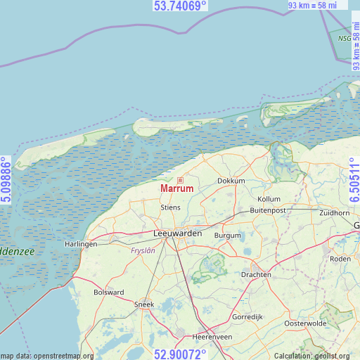
Marrum GPS coordinates[2]
53° 19' 21.972" North, 5° 48' 7.128" East
| Map corner | latitude | longitude |
|---|---|---|
| Upper-left | 53.74069°, | 5.09886° |
| Center: | 53.32277°, | 5.80198° |
| Lower-right: | 52.90072°, | 6.50511° |
| Map W x H: | 93.4×93.4 km | = 58×58mi |
| max Lat: | 53.48025° ⇑1.9% North |
| Marrum: | 53.32277° |
| min Lat: | ⇓98.1% South 50.76917° |
| min Long | Marrum | max Long |
| 3.38611° | 5.80198° | 7.16528° |
| W 57.8%⇐ | ⇒42.2% E |
Elevation
Elevation of Marrum is 3 m = 10 ft, and this is 12 m = 39 ft below average elevation for this country.
| Max E: |
203 m = 666 ft | 65.8% |
| Avg. | 15 m = 49 ft | |
| Marrum | 3 m = 10 ft | |
Min E: |
-6 m = -20 ft | 34.2% |
See also: Netherlands elevation on elevation.city.
Geographical zone
Marrum is located in North temperate zone (between Tropic of Cancer and the Arctic Circle). Distance of this North polar circle is 1472.2 km =914.8 mi to North.| Distance of | km | miles | from Marrum |
|---|---|---|---|
| North Pole | 4078.1 | 2534 | to North |
| Arctic Circle | 1472.2 | 914.8 | to North |
| Tropic Cancer | 3323 | 2064.8 | to South |
| Equator | 5928.9 | 3684 | to South |


Nearby cities:
15 places around Marrum: (largest is in red/bold)
• Aldtsjerk
8.4 km =5.2 mi,  137°
137°
• Blije
5.1 km =3.2 mi,  50°
50°
• Britsum
7.7 km =4.8 mi,  188°
188°
• Burdaard
6 km =3.7 mi,  121°
121°
• Ferwert
2.3 km =1.4 mi,  42°
42°
• Gytsjerk
10.8 km =6.7 mi,  145°
145°
• Hallum
2.2 km =1.4 mi,  213°
213°
• Holwerd
8.3 km =5.2 mi, 52°
• Mûnein
11.1 km =6.9 mi,  134°
134°
• Oentsjerk
10.4 km =6.5 mi, 141°
• Oude Bildtzijl
6.1 km =3.8 mi,  245°
245°
• Rinsumageast
10.2 km =6.3 mi,  106°
106°
• Sint Annaparochie
10.9 km =6.8 mi,  241°
241°
• Stiens
7.3 km =4.5 mi,  203°
203°
• Vrouwenparochie
8.3 km =5.2 mi,  234°
234°
Sources, notices
• [Note1] Compared only with cities in Netherlands existing in our database
• [Src1] Map data: © OpenStreetMap contributors (CC-BY-SA)
• [Src2] Other city data from geonames.org with taken over terms of usage.
• [Src3] Geographical zone / Annual Mean Temperature by Robert A. Rohde @ Wikipedia
