Blije geodata
Blije (Friesland) is a populated place; located in Netherlands in Europe/Amsterdam (GMT+2) time zone. With population of 610 people, there are 1710 cities with bigger population in this country. Compared to other cities in Netherlands, 98.6% of cities are located further ↓South; 61.6% of cities are located further ←West and 83.9% of cities have higher elevation than Blije. Note1


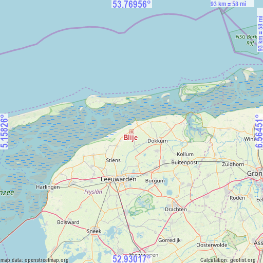
Blije GPS coordinates[2]
53° 21' 6.948" North, 5° 51' 40.968" East
| Map corner | latitude | longitude |
|---|---|---|
| Upper-left | 53.76956°, | 5.15826° |
| Center: | 53.35193°, | 5.86138° |
| Lower-right: | 52.93017°, | 6.56451° |
| Map W x H: | 93.3×93.3 km | = 58×58mi |
| max Lat: | 53.48025° ⇑1.4% North |
| Blije: | 53.35193° |
| min Lat: | ⇓98.6% South 50.76917° |
| min Long | Blije | max Long |
| 3.38611° | 5.86138° | 7.16528° |
| W 61.6%⇐ | ⇒38.4% E |
Elevation
Elevation of Blije is 1 m = 3 ft, and this is 14 m = 46 ft below average elevation for this country.
| Max E: |
203 m = 666 ft | 83.9% |
| Avg. | 15 m = 49 ft | |
| Blije | 1 m = 3 ft | |
Min E: |
-6 m = -20 ft | 16.1% |
See also: Netherlands elevation on elevation.city.
Geographical zone
Blije is located in North temperate zone (between Tropic of Cancer and the Arctic Circle). Distance of this North polar circle is 1469 km =912.8 mi to North.| Distance of | km | miles | from Blije |
|---|---|---|---|
| North Pole | 4074.9 | 2532 | to North |
| Arctic Circle | 1469 | 912.8 | to North |
| Tropic Cancer | 3326.3 | 2066.9 | to South |
| Equator | 5932.2 | 3686.1 | to South |


Nearby cities:
15 places around Blije: (largest is in red/bold)
• Aldtsjerk
9.7 km =6 mi,  169°
169°
• Burdaard
6.5 km =4 mi, 169°
• Buren
11.4 km =7.1 mi,  338°
338°
• Damwâld
11.4 km =7.1 mi,  127°
127°
• Dokkum
9.6 km =6 mi,  110°
110°
• Ferwert
2.9 km =1.8 mi,  236°
236°
• Hallum
7.2 km =4.5 mi,  225°
225°
• Holwerd
3.2 km =2 mi,  55°
55°
• Marrum
5.1 km =3.2 mi, 230°
• Mûnein
11.7 km =7.3 mi,  160°
160°
• Nes
11.9 km =7.4 mi,  330°
330°
• Oentsjerk
11.6 km =7.2 mi, 167°
• Oude Bildtzijl
11.1 km =6.9 mi, 238°
• Rinsumageast
8.5 km =5.3 mi,  136°
136°
• Ternaard
7.7 km =4.8 mi, 64°
Sources, notices
• [Note1] Compared only with cities in Netherlands existing in our database
• [Src1] Map data: © OpenStreetMap contributors (CC-BY-SA)
• [Src2] Other city data from geonames.org with taken over terms of usage.
• [Src3] Geographical zone / Annual Mean Temperature by Robert A. Rohde @ Wikipedia
