Maarssen geodata
Maarssen (Utrecht) is a populated place; located in Netherlands in Europe/Amsterdam (GMT+2) time zone. With population of 39,675 people, there are 80 cities with bigger population in this country. Compared to other cities in Netherlands, 56.5% of cities are located further ↓South; 72.5% of cities are located further →East and 58.8% of cities have higher elevation than Maarssen. Note1


Maarssen GPS coordinates[2]
52° 8' 21.012" North, 5° 2' 30.012" East
| Map corner | latitude | longitude |
|---|---|---|
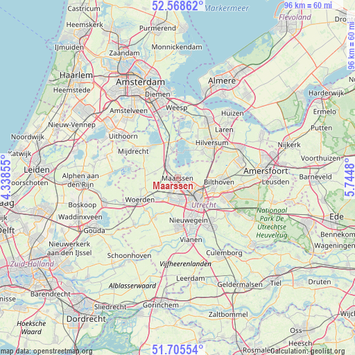
| Upper-left | 52.56862°, | 4.33855° |
| Center: | 52.13917°, | 5.04167° |
| Lower-right: | 51.70554°, | 5.7448° |
| Map W x H: | 96×96 km | = 59.7×59.7mi |
| max Lat: | 53.48025° ⇑43.5% North |
| Maarssen: | 52.13917° |
| min Lat: | ⇓56.5% South 50.76917° |
| min Long | Maarssen | max Long |
| 3.38611° | 5.04167° | 7.16528° |
| W 27.5%⇐ | ⇒72.5% E |
Elevation
Elevation of Maarssen is 4 m = 13 ft, and this is 11 m = 36 ft below average elevation for this country.
| Max E: |
203 m = 666 ft | 58.8% |
| Avg. | 15 m = 49 ft | |
| Maarssen | 4 m = 13 ft | |
Min E: |
-6 m = -20 ft | 41.2% |
See also: Netherlands elevation on elevation.city.
Geographical zone
Maarssen is located in North temperate zone (between Tropic of Cancer and the Arctic Circle). Distance of this North polar circle is 1603.8 km =996.6 mi to North.| Distance of | km | miles | from Maarssen |
|---|---|---|---|
| North Pole | 4209.7 | 2615.8 | to North |
| Arctic Circle | 1603.8 | 996.6 | to North |
| Tropic Cancer | 3191.4 | 1983 | to South |
| Equator | 5797.3 | 3602.3 | to South |


Nearby cities:
15 places around Maarssen: (largest is in red/bold)
• Breukelen
4.8 km =3 mi,  324°
324°
• De Bilt
10 km =6.2 mi,  108°
108°
• Groenekan
7.8 km =4.8 mi,  103°
103°
• Hollandsche Rading
10.1 km =6.3 mi,  66°
66°
• Lunetten
10.7 km =6.6 mi,  143°
143°
• Maarsseveen
2.2 km =1.4 mi,  84°
84°
• Maartensdijk
9.3 km =5.8 mi, 79°
• Nieuw-Loosdrecht
9.4 km =5.8 mi,  44°
44°
• Oog in Al
6.6 km =4.1 mi,  153°
153°
• Oud-Loosdrecht
8 km =5 mi,  19°
19°
• Oud-Zuilen
2.2 km =1.4 mi,  125°
125°
• Spechtenkamp
1.6 km =1 mi,  270°
270°
• Utrecht
7.7 km =4.8 mi, 134°
• Veldhuizen
7.4 km =4.6 mi,  195°
195°
• Vleuten
4.1 km =2.5 mi,  205°
205°
Sources, notices
• [Note1] Compared only with cities in Netherlands existing in our database
• [Src1] Map data: © OpenStreetMap contributors (CC-BY-SA)
• [Src2] Other city data from geonames.org with taken over terms of usage.
• [Src3] Geographical zone / Annual Mean Temperature by Robert A. Rohde @ Wikipedia
