Utrecht geodata
Utrecht is a seat of a first-order administrative division; located in Netherlands in Europe/Amsterdam (GMT+2) time zone. With population of 290,529 people, there are 3 cities with bigger population in this country. Compared to other cities in Netherlands, 54.4% of cities are located further ↓South; 69.2% of cities are located further →East and 67% of cities have lower elevation than Utrecht. Note1


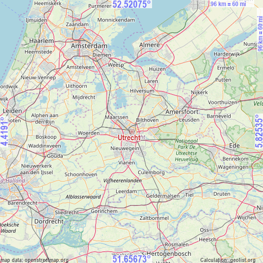
Utrecht GPS coordinates[2]
52° 5' 26.988" North, 5° 7' 19.992" East
| Map corner | latitude | longitude |
|---|---|---|
| Upper-left | 52.52075°, | 4.4191° |
| Center: | 52.09083°, | 5.12222° |
| Lower-right: | 51.65673°, | 5.82535° |
| Map W x H: | 96.1×96.1 km | = 59.7×59.7mi |
| max Lat: | 53.48025° ⇑45.6% North |
| Utrecht: | 52.09083° |
| min Lat: | ⇓54.4% South 50.76917° |
| min Long | Utrecht | max Long |
| 3.38611° | 5.12222° | 7.16528° |
| W 30.8%⇐ | ⇒69.2% E |
Elevation
Elevation of Utrecht is 13 m = 43 ft, and this is 2 m = 7 ft below average elevation for this country.
| Max E: |
203 m = 666 ft | 33% |
| Avg. | 15 m = 49 ft | |
| Utrecht | 13 m = 43 ft | |
Min E: |
-6 m = -20 ft | 67% |
See also: Utrecht elevation on elevation.city.
Geographical zone
Utrecht is located in North temperate zone (between Tropic of Cancer and the Arctic Circle). Distance of this North polar circle is 1609.2 km =999.9 mi to North.| Distance of | km | miles | from Utrecht |
|---|---|---|---|
| North Pole | 4215.1 | 2619.1 | to North |
| Arctic Circle | 1609.2 | 999.9 | to North |
| Tropic Cancer | 3186 | 1979.7 | to South |
| Equator | 5792 | 3599 | to South |


Nearby cities:
15 places around Utrecht: (largest is in red/bold)
• Bunnik
5.9 km =3.7 mi,  117°
117°
• De Bilt
4.5 km =2.8 mi,  61°
61°
• De Uithof
3.6 km =2.2 mi,  99°
99°
• Groenekan
4.2 km =2.6 mi,  30°
30°
• Houten
7.6 km =4.7 mi,  155°
155°
• Lunetten
3.3 km =2.1 mi,  165°
165°
• Maarssen
7.7 km =4.8 mi,  314°
314°
• Maarsseveen
6.5 km =4 mi,  329°
329°
• Nieuwegein
7.4 km =4.6 mi,  202°
202°
• Nijenheim
6.6 km =4.1 mi,  93°
93°
• Oog in Al
2.6 km =1.6 mi,  259°
259°
• Oud-Zuilen
5.5 km =3.4 mi,  317°
317°
• Veldhuizen
7.7 km =4.8 mi, 257°
• Vleuten
7.5 km =4.7 mi,  282°
282°
• Zeist
7.6 km =4.7 mi, 90°
Sources, notices
• [Note1] Compared only with cities in Netherlands existing in our database
• [Src1] Map data: © OpenStreetMap contributors (CC-BY-SA)
• [Src2] Other city data from geonames.org with taken over terms of usage.
• [Src3] Geographical zone / Annual Mean Temperature by Robert A. Rohde @ Wikipedia
