Oog in Al geodata
Oog in Al (Utrecht) is a section of populated place; located in Netherlands in Europe/Amsterdam (GMT+2) time zone. With population of 4,235 people, there are 565 cities with bigger population in this country. Compared to other cities in Netherlands, 54.1% of cities are located further ↓South; 70.7% of cities are located further →East and 50.6% of cities have higher elevation than Oog in Al. Note1


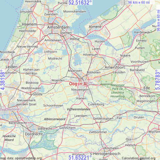
Oog in Al GPS coordinates[2]
52° 5' 10.896" North, 5° 5' 4.92" East
| Map corner | latitude | longitude |
|---|---|---|
| Upper-left | 52.51632°, | 4.38158° |
| Center: | 52.08636°, | 5.0847° |
| Lower-right: | 51.65221°, | 5.78783° |
| Map W x H: | 96.1×96.1 km | = 59.7×59.7mi |
| max Lat: | 53.48025° ⇑45.9% North |
| Oog in Al: | 52.08636° |
| min Lat: | ⇓54.1% South 50.76917° |
| min Long | Oog in Al | max Long |
| 3.38611° | 5.0847° | 7.16528° |
| W 29.3%⇐ | ⇒70.7% E |
Elevation
Elevation of Oog in Al is 6 m = 20 ft, and this is 9 m = 30 ft below average elevation for this country.
| Max E: |
203 m = 666 ft | 50.6% |
| Avg. | 15 m = 49 ft | |
| Oog in Al | 6 m = 20 ft | |
Min E: |
-6 m = -20 ft | 49.4% |
See also: Netherlands elevation on elevation.city.
Geographical zone
Oog in Al is located in North temperate zone (between Tropic of Cancer and the Arctic Circle). Distance of this North polar circle is 1609.7 km =1000.2 mi to North.| Distance of | km | miles | from Oog in Al |
|---|---|---|---|
| North Pole | 4215.6 | 2619.5 | to North |
| Arctic Circle | 1609.7 | 1000.2 | to North |
| Tropic Cancer | 3185.5 | 1979.4 | to South |
| Equator | 5791.5 | 3598.7 | to South |


Nearby cities:
15 places around Oog in Al: (largest is in red/bold)
• Bunnik
8.1 km =5 mi,  105°
105°
• De Bilt
7.1 km =4.4 mi,  68°
68°
• De Uithof
6.1 km =3.8 mi,  91°
91°
• Groenekan
6.2 km =3.9 mi,  48°
48°
• IJsselstein
7.9 km =4.9 mi,  201°
201°
• Lunetten
4.4 km =2.7 mi,  128°
128°
• Maarssen
6.6 km =4.1 mi,  333°
333°
• Maarsseveen
6.1 km =3.8 mi,  352°
352°
• Nieuwegein
6.4 km =4 mi,  182°
182°
• Oud-Zuilen
4.7 km =2.9 mi, 346°
• Spechtenkamp
7.5 km =4.7 mi,  322°
322°
• Utrecht
2.6 km =1.6 mi,  79°
79°
• Veldhuizen
5.1 km =3.2 mi,  256°
256°
• Vleuten
5.2 km =3.2 mi,  294°
294°
• Vreeswijk
8.4 km =5.2 mi, 176°
Sources, notices
• [Note1] Compared only with cities in Netherlands existing in our database
• [Src1] Map data: © OpenStreetMap contributors (CC-BY-SA)
• [Src2] Other city data from geonames.org with taken over terms of usage.
• [Src3] Geographical zone / Annual Mean Temperature by Robert A. Rohde @ Wikipedia
