Linschoten geodata
Linschoten (Utrecht) is a populated place; located in Netherlands in Europe/Amsterdam (GMT+2) time zone. With population of 3,435 people, there are 693 cities with bigger population in this country. Compared to other cities in Netherlands, 52.5% of cities are located further ↓South; 75.8% of cities are located further →East and 91.3% of cities have higher elevation than Linschoten. Note1


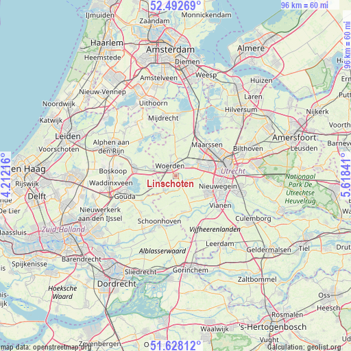
Linschoten GPS coordinates[2]
52° 3' 45" North, 4° 54' 55.008" East
| Map corner | latitude | longitude |
|---|---|---|
| Upper-left | 52.49269°, | 4.21216° |
| Center: | 52.0625°, | 4.91528° |
| Lower-right: | 51.62812°, | 5.61841° |
| Map W x H: | 96.1×96.1 km | = 59.7×59.7mi |
| max Lat: | 53.48025° ⇑47.5% North |
| Linschoten: | 52.0625° |
| min Lat: | ⇓52.5% South 50.76917° |
| min Long | Linschoten | max Long |
| 3.38611° | 4.91528° | 7.16528° |
| W 24.2%⇐ | ⇒75.8% E |
Elevation
Elevation of Linschoten is 0 m = 0 ft, and this is 15 m = 49 ft below average elevation for this country.
| Max E: |
203 m = 666 ft | 91.3% |
| Avg. | 15 m = 49 ft | |
| Linschoten | 0 m = 0 ft | |
Min E: |
-6 m = -20 ft | 8.7% |
See also: Netherlands elevation on elevation.city.
Geographical zone
Linschoten is located in North temperate zone (between Tropic of Cancer and the Arctic Circle). Distance of this North polar circle is 1612.4 km =1001.9 mi to North.| Distance of | km | miles | from Linschoten |
|---|---|---|---|
| North Pole | 4218.3 | 2621.1 | to North |
| Arctic Circle | 1612.4 | 1001.9 | to North |
| Tropic Cancer | 3182.9 | 1977.8 | to South |
| Equator | 5788.8 | 3597 | to South |


Nearby cities:
15 places around Linschoten: (largest is in red/bold)
• Driebruggen
8.1 km =5 mi,  255°
255°
• Graaf
10.1 km =6.3 mi,  154°
154°
• Heeswijk
3.9 km =2.4 mi,  108°
108°
• IJsselstein
9.9 km =6.2 mi,  118°
118°
• Lopik
10.3 km =6.4 mi,  167°
167°
• Montfoort
3.2 km =2 mi,  125°
125°
• Oudewater
5.3 km =3.3 mi,  217°
217°
• Snelrewaard
3.9 km =2.4 mi,  186°
186°
• Veldhuizen
6.8 km =4.2 mi,  77°
77°
• Vleuten
8.4 km =5.2 mi,  54°
54°
• Waarder
6.5 km =4 mi,  268°
268°
• Weijpoort
8 km =5 mi,  285°
285°
• Woerden
3.3 km =2.1 mi,  318°
318°
• Woerdense Verlaat
10.9 km =6.8 mi,  341°
341°
• Zuidzijde
10 km =6.2 mi,  281°
281°
Sources, notices
• [Note1] Compared only with cities in Netherlands existing in our database
• [Src1] Map data: © OpenStreetMap contributors (CC-BY-SA)
• [Src2] Other city data from geonames.org with taken over terms of usage.
• [Src3] Geographical zone / Annual Mean Temperature by Robert A. Rohde @ Wikipedia
