Woerden geodata
Woerden (Utrecht) is a populated place; located in Netherlands in Europe/Amsterdam (GMT+2) time zone. With population of 48,431 people, there are 62 cities with bigger population in this country. Compared to other cities in Netherlands, 53.8% of cities are located further ↓South; 76.9% of cities are located further →East and 58.8% of cities have higher elevation than Woerden. Note1


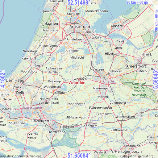
Woerden GPS coordinates[2]
52° 5' 6" North, 4° 52' 59.988" East
| Map corner | latitude | longitude |
|---|---|---|
| Upper-left | 52.51498°, | 4.1802° |
| Center: | 52.085°, | 4.88333° |
| Lower-right: | 51.65084°, | 5.58645° |
| Map W x H: | 96.1×96.1 km | = 59.7×59.7mi |
| max Lat: | 53.48025° ⇑46.2% North |
| Woerden: | 52.085° |
| min Lat: | ⇓53.8% South 50.76917° |
| min Long | Woerden | max Long |
| 3.38611° | 4.88333° | 7.16528° |
| W 23.1%⇐ | ⇒76.9% E |
Elevation
Elevation of Woerden is 4 m = 13 ft, and this is 11 m = 36 ft below average elevation for this country.
| Max E: |
203 m = 666 ft | 58.8% |
| Avg. | 15 m = 49 ft | |
| Woerden | 4 m = 13 ft | |
Min E: |
-6 m = -20 ft | 41.2% |
See also: Woerden elevation on elevation.city.
Geographical zone
Woerden is located in North temperate zone (between Tropic of Cancer and the Arctic Circle). Distance of this North polar circle is 1609.9 km =1000.3 mi to North.| Distance of | km | miles | from Woerden |
|---|---|---|---|
| North Pole | 4215.8 | 2619.6 | to North |
| Arctic Circle | 1609.9 | 1000.3 | to North |
| Tropic Cancer | 3185.4 | 1979.3 | to South |
| Equator | 5791.3 | 3598.5 | to South |


Nearby cities:
15 places around Woerden: (largest is in red/bold)
• Bodegraven
9.1 km =5.7 mi,  268°
268°
• Driebruggen
7.3 km =4.5 mi,  231°
231°
• Heeswijk
7 km =4.3 mi,  122°
122°
• Linschoten
3.3 km =2.1 mi,  138°
138°
• Montfoort
6.4 km =4 mi,  132°
132°
• Nieuwkoop
10.3 km =6.4 mi,  315°
315°
• Oudewater
6.8 km =4.2 mi,  188°
188°
• Snelrewaard
6.6 km =4.1 mi,  165°
165°
• Spechtenkamp
11 km =6.8 mi,  56°
56°
• Veldhuizen
8.9 km =5.5 mi,  96°
96°
• Vleuten
9.3 km =5.8 mi,  75°
75°
• Waarder
5 km =3.1 mi,  237°
237°
• Weijpoort
5.5 km =3.4 mi, 266°
• Woerdense Verlaat
7.9 km =4.9 mi,  350°
350°
• Zuidzijde
7.6 km =4.7 mi, 265°
Sources, notices
• [Note1] Compared only with cities in Netherlands existing in our database
• [Src1] Map data: © OpenStreetMap contributors (CC-BY-SA)
• [Src2] Other city data from geonames.org with taken over terms of usage.
• [Src3] Geographical zone / Annual Mean Temperature by Robert A. Rohde @ Wikipedia
