Limmen geodata
Limmen (North Holland) is a populated place; located in Netherlands in Europe/Amsterdam (GMT+2) time zone. With population of 7,300 people, there are 353 cities with bigger population in this country. Compared to other cities in Netherlands, 73.2% of cities are located further ↓South; 83.2% of cities are located further →East and 65.8% of cities have higher elevation than Limmen. Note1


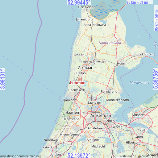
Limmen GPS coordinates[2]
52° 34' 9.012" North, 4° 41' 39.984" East
| Map corner | latitude | longitude |
|---|---|---|
| Upper-left | 52.99445°, | 3.99131° |
| Center: | 52.56917°, | 4.69444° |
| Lower-right: | 52.13972°, | 5.39756° |
| Map W x H: | 95×95 km | = 59×59mi |
| max Lat: | 53.48025° ⇑26.8% North |
| Limmen: | 52.56917° |
| min Lat: | ⇓73.2% South 50.76917° |
| min Long | Limmen | max Long |
| 3.38611° | 4.69444° | 7.16528° |
| W 16.8%⇐ | ⇒83.2% E |
Elevation
Elevation of Limmen is 3 m = 10 ft, and this is 12 m = 39 ft below average elevation for this country.
| Max E: |
203 m = 666 ft | 65.8% |
| Avg. | 15 m = 49 ft | |
| Limmen | 3 m = 10 ft | |
Min E: |
-6 m = -20 ft | 34.2% |
See also: Netherlands elevation on elevation.city.
Geographical zone
Limmen is located in North temperate zone (between Tropic of Cancer and the Arctic Circle). Distance of this North polar circle is 1556 km =966.9 mi to North.| Distance of | km | miles | from Limmen |
|---|---|---|---|
| North Pole | 4161.9 | 2586.1 | to North |
| Arctic Circle | 1556 | 966.9 | to North |
| Tropic Cancer | 3239.2 | 2012.7 | to South |
| Equator | 5845.1 | 3632 | to South |


Nearby cities:
15 places around Limmen: (largest is in red/bold)
• Alkmaar
7.9 km =4.9 mi,  27°
27°
• Castricum
2.9 km =1.8 mi,  216°
216°
• Commandeurs
7.1 km =4.4 mi,  200°
200°
• De Maer
5.6 km =3.5 mi,  188°
188°
• Egmond aan Zee
7.3 km =4.5 mi,  321°
321°
• Egmond-Binnen
4 km =2.5 mi, 318°
• Heemskerk
6.6 km =4.1 mi, 193°
• Heemskerkerduin
8.1 km =5 mi,  211°
211°
• Heiloo
3.7 km =2.3 mi,  353°
353°
• Oosterzij
1.9 km =1.2 mi,  23°
23°
• Oostknollendam
8.7 km =5.4 mi,  131°
131°
• Uitgeest
4.6 km =2.9 mi,  166°
166°
• Waterakkers
7.7 km =4.8 mi, 199°
• West-Graftdijk
7.1 km =4.4 mi,  103°
103°
• Zuidschermer
6 km =3.7 mi,  72°
72°
Sources, notices
• [Note1] Compared only with cities in Netherlands existing in our database
• [Src1] Map data: © OpenStreetMap contributors (CC-BY-SA)
• [Src2] Other city data from geonames.org with taken over terms of usage.
• [Src3] Geographical zone / Annual Mean Temperature by Robert A. Rohde @ Wikipedia
