Heemskerk geodata
Heemskerk (North Holland) is a seat of a second-order administrative division; located in Netherlands in Europe/Amsterdam (GMT+2) time zone. With population of 36,170 people, there are 89 cities with bigger population in this country. Compared to other cities in Netherlands, 71.7% of cities are located further ↓South; 83.8% of cities are located further →East and 54.1% of cities have higher elevation than Heemskerk. Note1


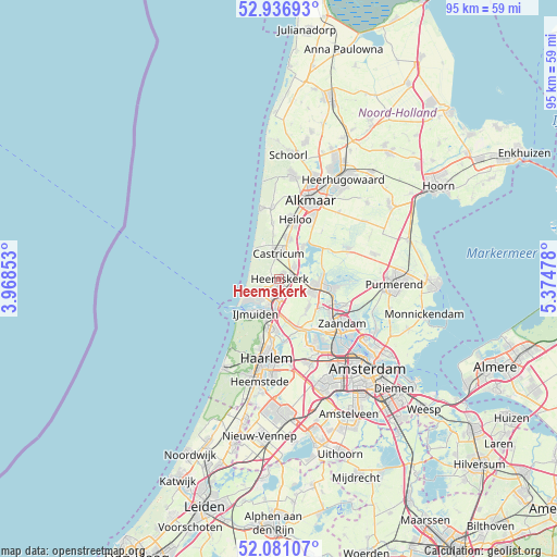
Heemskerk GPS coordinates[2]
52° 30' 39.888" North, 4° 40' 17.94" East
| Map corner | latitude | longitude |
|---|---|---|
| Upper-left | 52.93693°, | 3.96853° |
| Center: | 52.51108°, | 4.67165° |
| Lower-right: | 52.08107°, | 5.37478° |
| Map W x H: | 95.2×95.2 km | = 59.2×59.2mi |
| max Lat: | 53.48025° ⇑28.3% North |
| Heemskerk: | 52.51108° |
| min Lat: | ⇓71.7% South 50.76917° |
| min Long | Heemskerk | max Long |
| 3.38611° | 4.67165° | 7.16528° |
| W 16.2%⇐ | ⇒83.8% E |
Elevation
Elevation of Heemskerk is 5 m = 16 ft, and this is 10 m = 33 ft below average elevation for this country.
| Max E: |
203 m = 666 ft | 54.1% |
| Avg. | 15 m = 49 ft | |
| Heemskerk | 5 m = 16 ft | |
Min E: |
-6 m = -20 ft | 45.9% |
See also: Netherlands elevation on elevation.city.
Geographical zone
Heemskerk is located in North temperate zone (between Tropic of Cancer and the Arctic Circle). Distance of this North polar circle is 1562.5 km =970.9 mi to North.| Distance of | km | miles | from Heemskerk |
|---|---|---|---|
| North Pole | 4168.4 | 2590.1 | to North |
| Arctic Circle | 1562.5 | 970.9 | to North |
| Tropic Cancer | 3232.8 | 2008.8 | to South |
| Equator | 5838.7 | 3628 | to South |


Nearby cities:
15 places around Heemskerk: (largest is in red/bold)
• Beverwijk
3.2 km =2 mi,  197°
197°
• Castricum
4.1 km =2.5 mi,  357°
357°
• Commandeurs
0.9 km =0.6 mi,  255°
255°
• De Maer
1.1 km =0.7 mi,  37°
37°
• Egmond-Binnen
9.5 km =5.9 mi,  353°
353°
• Heemskerkerduin
2.7 km =1.7 mi, 261°
• Hofgeest
7.6 km =4.7 mi,  186°
186°
• Langeheit
6.2 km =3.9 mi,  109°
109°
• Limmen
6.6 km =4.1 mi,  13°
13°
• Oosterzij
8.5 km =5.3 mi,  15°
15°
• Oostknollendam
8.2 km =5.1 mi,  84°
84°
• Uitgeest
3.3 km =2.1 mi,  52°
52°
• Velsen-Zuid
5.9 km =3.7 mi, 194°
• Waterakkers
1.3 km =0.8 mi,  234°
234°
• Wijk aan Zee
5.6 km =3.5 mi,  249°
249°
Sources, notices
• [Note1] Compared only with cities in Netherlands existing in our database
• [Src1] Map data: © OpenStreetMap contributors (CC-BY-SA)
• [Src2] Other city data from geonames.org with taken over terms of usage.
• [Src3] Geographical zone / Annual Mean Temperature by Robert A. Rohde @ Wikipedia
