West-Graftdijk geodata
West-Graftdijk (North Holland) is a populated place; located in Netherlands in Europe/Amsterdam (GMT+2) time zone. With population of 670 people, there are 1656 cities with bigger population in this country. Compared to other cities in Netherlands, 72.8% of cities are located further ↓South; 79.9% of cities are located further →East and 96.1% of cities have higher elevation than West-Graftdijk. Note1


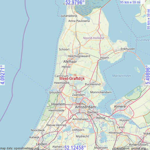
West-Graftdijk GPS coordinates[2]
52° 33' 15.012" North, 4° 47' 44.988" East
| Map corner | latitude | longitude |
|---|---|---|
| Upper-left | 52.9796°, | 4.09271° |
| Center: | 52.55417°, | 4.79583° |
| Lower-right: | 52.12458°, | 5.49896° |
| Map W x H: | 95.1×95.1 km | = 59.1×59.1mi |
| max Lat: | 53.48025° ⇑27.2% North |
| West-Graftdijk: | 52.55417° |
| min Lat: | ⇓72.8% South 50.76917° |
| min Long | West-Graftdijk | max Long |
| 3.38611° | 4.79583° | 7.16528° |
| W 20.1%⇐ | ⇒79.9% E |
Elevation
Elevation of West-Graftdijk is -1 m = -3 ft, and this is 16 m = 52 ft below average elevation for this country.
| Max E: |
203 m = 666 ft | 96.1% |
| Avg. | 15 m = 49 ft | |
| West-Graftdijk | -1 m = -3 ft | |
Min E: |
-6 m = -20 ft | 3.9% |
See also: Netherlands elevation on elevation.city.
Geographical zone
West-Graftdijk is located in North temperate zone (between Tropic of Cancer and the Arctic Circle). Distance of this North polar circle is 1557.7 km =967.9 mi to North.| Distance of | km | miles | from West-Graftdijk |
|---|---|---|---|
| North Pole | 4163.6 | 2587.1 | to North |
| Arctic Circle | 1557.7 | 967.9 | to North |
| Tropic Cancer | 3237.6 | 2011.8 | to South |
| Equator | 5843.5 | 3631 | to South |


Nearby cities:
15 places around West-Graftdijk: (largest is in red/bold)
• Castricum
8.6 km =5.3 mi,  265°
265°
• De Maer
8.7 km =5.4 mi,  243°
243°
• De Rijp
3.4 km =2.1 mi,  85°
85°
• Graft
2.5 km =1.6 mi,  72°
72°
• Grootschermer
4.8 km =3 mi,  49°
49°
• Langeheit
7.4 km =4.6 mi,  200°
200°
• Limmen
7.1 km =4.4 mi,  283°
283°
• Middenbeemster
7.9 km =4.9 mi, 94°
• Oosterzij
7 km =4.3 mi,  299°
299°
• Oostknollendam
4.1 km =2.5 mi,  183°
183°
• Schermerhorn
8.3 km =5.2 mi, 51°
• Stompetoren
6.8 km =4.2 mi,  14°
14°
• Uitgeest
6.5 km =4 mi, 244°
• Zaandijk
8.8 km =5.5 mi, 175°
• Zuidschermer
3.6 km =2.2 mi,  341°
341°
Sources, notices
• [Note1] Compared only with cities in Netherlands existing in our database
• [Src1] Map data: © OpenStreetMap contributors (CC-BY-SA)
• [Src2] Other city data from geonames.org with taken over terms of usage.
• [Src3] Geographical zone / Annual Mean Temperature by Robert A. Rohde @ Wikipedia
