Alkmaar geodata
Alkmaar (North Holland) is a populated place; located in Netherlands in Europe/Amsterdam (GMT+2) time zone. With population of 94,853 people, there are 25 cities with bigger population in this country. Compared to other cities in Netherlands, 74.3% of cities are located further ↓South; 82% of cities are located further →East and 54.1% of cities have higher elevation than Alkmaar. Note1


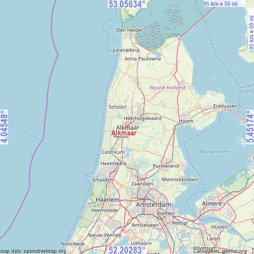
Alkmaar GPS coordinates[2]
52° 37' 54.012" North, 4° 44' 54.996" East
| Map corner | latitude | longitude |
|---|---|---|
| Upper-left | 53.05634°, | 4.04549° |
| Center: | 52.63167°, | 4.74861° |
| Lower-right: | 52.20283°, | 5.45174° |
| Map W x H: | 94.9×94.9 km | = 59×59mi |
| max Lat: | 53.48025° ⇑25.7% North |
| Alkmaar: | 52.63167° |
| min Lat: | ⇓74.3% South 50.76917° |
| min Long | Alkmaar | max Long |
| 3.38611° | 4.74861° | 7.16528° |
| W 18%⇐ | ⇒82% E |
Elevation
Elevation of Alkmaar is 5 m = 16 ft, and this is 10 m = 33 ft below average elevation for this country.
| Max E: |
203 m = 666 ft | 54.1% |
| Avg. | 15 m = 49 ft | |
| Alkmaar | 5 m = 16 ft | |
Min E: |
-6 m = -20 ft | 45.9% |
See also: Alkmaar elevation on elevation.city.
Geographical zone
Alkmaar is located in North temperate zone (between Tropic of Cancer and the Arctic Circle). Distance of this North polar circle is 1549.1 km =962.6 mi to North.| Distance of | km | miles | from Alkmaar |
|---|---|---|---|
| North Pole | 4155 | 2581.8 | to North |
| Arctic Circle | 1549.1 | 962.6 | to North |
| Tropic Cancer | 3246.2 | 2017.1 | to South |
| Equator | 5852.1 | 3636.3 | to South |


Nearby cities:
15 places around Alkmaar: (largest is in red/bold)
• Aagtdorp
7.1 km =4.4 mi,  335°
335°
• Bergen
5.1 km =3.2 mi,  324°
324°
• Broek op Langedijk
6.1 km =3.8 mi,  39°
39°
• Egmond aan Zee
8.3 km =5.2 mi,  261°
261°
• Egmond-Binnen
7.4 km =4.6 mi,  237°
237°
• Heerhugowaard
8.1 km =5 mi,  56°
56°
• Heiloo
5.2 km =3.2 mi,  231°
231°
• Limmen
7.9 km =4.9 mi,  207°
207°
• Noord-Scharwoude
8.5 km =5.3 mi,  29°
29°
• Oosterzij
5.9 km =3.7 mi, 209°
• Oterleek
5.8 km =3.6 mi,  84°
84°
• Sint Pancras
3.9 km =2.4 mi, 36°
• Stompetoren
5.3 km =3.3 mi,  112°
112°
• Zuid-Scharwoude
7.3 km =4.5 mi, 33°
• Zuidschermer
5.6 km =3.5 mi,  158°
158°
Sources, notices
• [Note1] Compared only with cities in Netherlands existing in our database
• [Src1] Map data: © OpenStreetMap contributors (CC-BY-SA)
• [Src2] Other city data from geonames.org with taken over terms of usage.
• [Src3] Geographical zone / Annual Mean Temperature by Robert A. Rohde @ Wikipedia
