Oosterzij geodata
Oosterzij (North Holland) is a populated place; located in Netherlands in Europe/Amsterdam (GMT+2) time zone. With population of 2,095 people, there are 934 cities with bigger population in this country. Compared to other cities in Netherlands, 73.6% of cities are located further ↓South; 82.9% of cities are located further →East and 83.9% of cities have higher elevation than Oosterzij. Note1


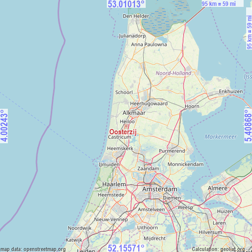
Oosterzij GPS coordinates[2]
52° 35' 6" North, 4° 42' 20.016" East
| Map corner | latitude | longitude |
|---|---|---|
| Upper-left | 53.01013°, | 4.00243° |
| Center: | 52.585°, | 4.70556° |
| Lower-right: | 52.15571°, | 5.40868° |
| Map W x H: | 95×95 km | = 59×59mi |
| max Lat: | 53.48025° ⇑26.4% North |
| Oosterzij: | 52.585° |
| min Lat: | ⇓73.6% South 50.76917° |
| min Long | Oosterzij | max Long |
| 3.38611° | 4.70556° | 7.16528° |
| W 17.1%⇐ | ⇒82.9% E |
Elevation
Elevation of Oosterzij is 1 m = 3 ft, and this is 14 m = 46 ft below average elevation for this country.
| Max E: |
203 m = 666 ft | 83.9% |
| Avg. | 15 m = 49 ft | |
| Oosterzij | 1 m = 3 ft | |
Min E: |
-6 m = -20 ft | 16.1% |
See also: Netherlands elevation on elevation.city.
Geographical zone
Oosterzij is located in North temperate zone (between Tropic of Cancer and the Arctic Circle). Distance of this North polar circle is 1554.3 km =965.8 mi to North.| Distance of | km | miles | from Oosterzij |
|---|---|---|---|
| North Pole | 4160.2 | 2585 | to North |
| Arctic Circle | 1554.3 | 965.8 | to North |
| Tropic Cancer | 3241 | 2013.9 | to South |
| Equator | 5846.9 | 3633.1 | to South |


Nearby cities:
15 places around Oosterzij: (largest is in red/bold)
• Alkmaar
5.9 km =3.7 mi,  29°
29°
• Bergen
9.4 km =5.8 mi,  359°
359°
• Castricum
4.8 km =3 mi,  210°
210°
• Commandeurs
9 km =5.6 mi,  200°
200°
• De Maer
7.5 km =4.7 mi,  192°
192°
• Egmond aan Zee
6.6 km =4.1 mi,  306°
306°
• Egmond-Binnen
3.6 km =2.2 mi,  289°
289°
• Graft
8.9 km =5.5 mi,  107°
107°
• Heemskerk
8.5 km =5.3 mi, 195°
• Heiloo
2.3 km =1.4 mi,  328°
328°
• Limmen
1.9 km =1.2 mi, 203°
• Stompetoren
8.4 km =5.2 mi,  67°
67°
• Uitgeest
6.2 km =3.9 mi,  177°
177°
• West-Graftdijk
7 km =4.3 mi,  119°
119°
• Zuidschermer
5 km =3.1 mi,  90°
90°
Sources, notices
• [Note1] Compared only with cities in Netherlands existing in our database
• [Src1] Map data: © OpenStreetMap contributors (CC-BY-SA)
• [Src2] Other city data from geonames.org with taken over terms of usage.
• [Src3] Geographical zone / Annual Mean Temperature by Robert A. Rohde @ Wikipedia
