Heiloo geodata
Heiloo (North Holland) is a seat of a second-order administrative division; located in Netherlands in Europe/Amsterdam (GMT+2) time zone. With population of 20,510 people, there are 167 cities with bigger population in this country. Compared to other cities in Netherlands, 74% of cities are located further ↓South; 83.4% of cities are located further →East and 74.9% of cities have higher elevation than Heiloo. Note1


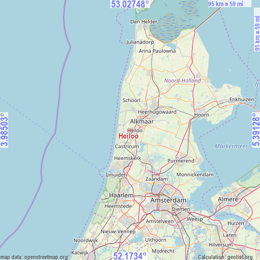
Heiloo GPS coordinates[2]
52° 36' 9.072" North, 4° 41' 17.34" East
| Map corner | latitude | longitude |
|---|---|---|
| Upper-left | 53.02748°, | 3.98503° |
| Center: | 52.60252°, | 4.68815° |
| Lower-right: | 52.1734°, | 5.39128° |
| Map W x H: | 95×95 km | = 59×59mi |
| max Lat: | 53.48025° ⇑26% North |
| Heiloo: | 52.60252° |
| min Lat: | ⇓74% South 50.76917° |
| min Long | Heiloo | max Long |
| 3.38611° | 4.68815° | 7.16528° |
| W 16.6%⇐ | ⇒83.4% E |
Elevation
Elevation of Heiloo is 2 m = 7 ft, and this is 13 m = 43 ft below average elevation for this country.
| Max E: |
203 m = 666 ft | 74.9% |
| Avg. | 15 m = 49 ft | |
| Heiloo | 2 m = 7 ft | |
Min E: |
-6 m = -20 ft | 25.1% |
See also: Netherlands elevation on elevation.city.
Geographical zone
Heiloo is located in North temperate zone (between Tropic of Cancer and the Arctic Circle). Distance of this North polar circle is 1552.3 km =964.6 mi to North.| Distance of | km | miles | from Heiloo |
|---|---|---|---|
| North Pole | 4158.2 | 2583.8 | to North |
| Arctic Circle | 1552.3 | 964.6 | to North |
| Tropic Cancer | 3242.9 | 2015 | to South |
| Equator | 5848.9 | 3634.3 | to South |


Nearby cities:
15 places around Heiloo: (largest is in red/bold)
• Aagtdorp
9.8 km =6.1 mi,  6°
6°
• Alkmaar
5.2 km =3.2 mi,  51°
51°
• Bergen
7.5 km =4.7 mi, 8°
• Castricum
6.2 km =3.9 mi,  191°
191°
• De Maer
9.3 km =5.8 mi,  182°
182°
• Egmond aan Zee
4.6 km =2.9 mi,  295°
295°
• Egmond-Binnen
2.3 km =1.4 mi,  251°
251°
• Heemskerk
10.2 km =6.3 mi, 186°
• Limmen
3.7 km =2.3 mi,  173°
173°
• Oosterzij
2.3 km =1.4 mi,  148°
148°
• Sint Pancras
9.1 km =5.7 mi, 45°
• Stompetoren
9 km =5.6 mi,  82°
82°
• Uitgeest
8.3 km =5.2 mi, 169°
• West-Graftdijk
9 km =5.6 mi,  126°
126°
• Zuidschermer
6.4 km =4 mi,  107°
107°
Sources, notices
• [Note1] Compared only with cities in Netherlands existing in our database
• [Src1] Map data: © OpenStreetMap contributors (CC-BY-SA)
• [Src2] Other city data from geonames.org with taken over terms of usage.
• [Src3] Geographical zone / Annual Mean Temperature by Robert A. Rohde @ Wikipedia
