Lieren geodata
Lieren (Gelderland) is a populated place; located in Netherlands in Europe/Amsterdam (GMT+2) time zone. With population of 570 people, there are 1754 cities with bigger population in this country. Compared to other cities in Netherlands, 57.8% of cities are located further ↓South; 71.8% of cities are located further ←West and 77.1% of cities have lower elevation than Lieren. Note1


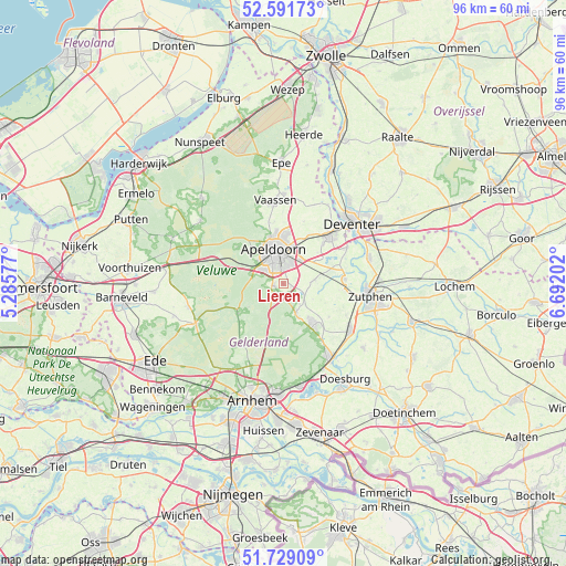
Lieren GPS coordinates[2]
52° 9' 45" North, 5° 59' 20.004" East
| Map corner | latitude | longitude |
|---|---|---|
| Upper-left | 52.59173°, | 5.28577° |
| Center: | 52.1625°, | 5.98889° |
| Lower-right: | 51.72909°, | 6.69202° |
| Map W x H: | 95.9×95.9 km | = 59.6×59.6mi |
| max Lat: | 53.48025° ⇑42.2% North |
| Lieren: | 52.1625° |
| min Lat: | ⇓57.8% South 50.76917° |
| min Long | Lieren | max Long |
| 3.38611° | 5.98889° | 7.16528° |
| W 71.8%⇐ | ⇒28.2% E |
Elevation
Elevation of Lieren is 19 m = 62 ft, and this is 4 m = 13 ft above average elevation for this country.
| Max E: |
203 m = 666 ft | 22.9% |
| Lieren | 19 m 62 ft | |
| Avg. | 15 m = 49 ft | |
Min E: |
-6 m = -20 ft | 77.1% |
See also: Netherlands elevation on elevation.city.
Geographical zone
Lieren is located in North temperate zone (between Tropic of Cancer and the Arctic Circle). Distance of this North polar circle is 1601.2 km =994.9 mi to North.| Distance of | km | miles | from Lieren |
|---|---|---|---|
| North Pole | 4207.1 | 2614.2 | to North |
| Arctic Circle | 1601.2 | 994.9 | to North |
| Tropic Cancer | 3194 | 1984.7 | to South |
| Equator | 5799.9 | 3603.9 | to South |


Nearby cities:
15 places around Lieren: (largest is in red/bold)
• Beekbergen
1.7 km =1.1 mi,  260°
260°
• Componistenkwartier
3.4 km =2.1 mi,  332°
332°
• De Bouwhof
3.8 km =2.4 mi,  311°
311°
• Matendonk
4.2 km =2.6 mi,  21°
21°
• Matendreef
4.2 km =2.6 mi,  357°
357°
• Matengaarde
4 km =2.5 mi,  6°
6°
• Matenhoeve
3.5 km =2.2 mi,  28°
28°
• Matenveld
2.9 km =1.8 mi, 13°
• Oosterhuizen
1.3 km =0.8 mi,  117°
117°
• Rivierenkwartier
3.1 km =1.9 mi,  344°
344°
• Staatsliedenkwartier
4.2 km =2.6 mi,  348°
348°
• Ugchelen
4.6 km =2.9 mi,  302°
302°
• Vogelkwartier
4.2 km =2.6 mi, 339°
• Westenenk
4.4 km =2.7 mi, 329°
• Winkewijert
3.8 km =2.4 mi, 326°
Sources, notices
• [Note1] Compared only with cities in Netherlands existing in our database
• [Src1] Map data: © OpenStreetMap contributors (CC-BY-SA)
• [Src2] Other city data from geonames.org with taken over terms of usage.
• [Src3] Geographical zone / Annual Mean Temperature by Robert A. Rohde @ Wikipedia
