Rivierenkwartier geodata
Rivierenkwartier (Gelderland) is a section of populated place; located in Netherlands in Europe/Amsterdam (GMT+2) time zone. With population of 2,940 people, there are 765 cities with bigger population in this country. Compared to other cities in Netherlands, 59.2% of cities are located further ↓South; 70.8% of cities are located further ←West and 70.6% of cities have lower elevation than Rivierenkwartier. Note1


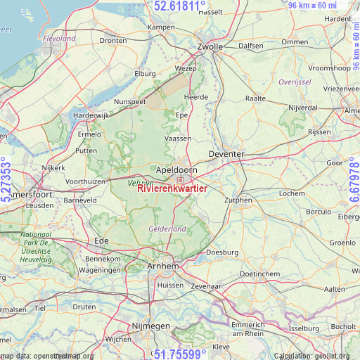
Rivierenkwartier GPS coordinates[2]
52° 11' 20.904" North, 5° 58' 35.94" East
| Map corner | latitude | longitude |
|---|---|---|
| Upper-left | 52.61811°, | 5.27353° |
| Center: | 52.18914°, | 5.97665° |
| Lower-right: | 51.75599°, | 6.67978° |
| Map W x H: | 95.9×95.9 km | = 59.6×59.6mi |
| max Lat: | 53.48025° ⇑40.8% North |
| Rivierenkwartier: | 52.18914° |
| min Lat: | ⇓59.2% South 50.76917° |
| min Long | Rivierenkwartie | max Long |
| 3.38611° | 5.97665° | 7.16528° |
| W 70.8%⇐ | ⇒29.2% E |
Elevation
Elevation of Rivierenkwartier is 15 m = 49 ft, and this is 0 m = 0 ft above average elevation for this country.
| Max E: |
203 m = 666 ft | 29.4% |
| Rivierenkwartier | 15 m 49 ft | |
| Avg. | 15 m = 49 ft | |
Min E: |
-6 m = -20 ft | 70.6% |
See also: Netherlands elevation on elevation.city.
Geographical zone
Rivierenkwartier is located in North temperate zone (between Tropic of Cancer and the Arctic Circle). Distance of this North polar circle is 1598.3 km =993.1 mi to North.| Distance of | km | miles | from Rivierenkwartier |
|---|---|---|---|
| North Pole | 4204.2 | 2612.4 | to North |
| Arctic Circle | 1598.3 | 993.1 | to North |
| Tropic Cancer | 3197 | 1986.5 | to South |
| Equator | 5802.9 | 3605.8 | to South |


Nearby cities:
15 places around Rivierenkwartier: (largest is in red/bold)
• Apeldoorn
2.4 km =1.5 mi,  348°
348°
• Brummelhof
1.9 km =1.2 mi,  341°
341°
• Componistenkwartier
0.7 km =0.4 mi,  275°
275°
• De Bouwhof
2.1 km =1.3 mi,  258°
258°
• De Haven
2.4 km =1.5 mi,  355°
355°
• De Heeze
2 km =1.2 mi,  309°
309°
• Matendonk
2.5 km =1.6 mi,  68°
68°
• Matendreef
1.4 km =0.9 mi,  27°
27°
• Matengaarde
1.6 km =1 mi,  53°
53°
• Matenhorst
2.1 km =1.3 mi, 32°
• Matenveld
1.5 km =0.9 mi,  96°
96°
• Staatsliedenkwartier
1.2 km =0.7 mi,  0°
0°
• Vogelkwartier
1.2 km =0.7 mi,  326°
326°
• Westenenk
1.6 km =1 mi,  299°
299°
• Winkewijert
1.3 km =0.8 mi, 278°
Sources, notices
• [Note1] Compared only with cities in Netherlands existing in our database
• [Src1] Map data: © OpenStreetMap contributors (CC-BY-SA)
• [Src2] Other city data from geonames.org with taken over terms of usage.
• [Src3] Geographical zone / Annual Mean Temperature by Robert A. Rohde @ Wikipedia
