Matengaarde geodata
Matengaarde (Gelderland) is a section of populated place; located in Netherlands in Europe/Amsterdam (GMT+2) time zone. With population of 2,810 people, there are 782 cities with bigger population in this country. Compared to other cities in Netherlands, 60.2% of cities are located further ↓South; 72.5% of cities are located further ←West and 70.6% of cities have lower elevation than Matengaarde. Note1


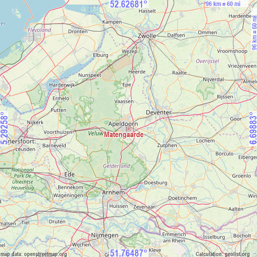
Matengaarde GPS coordinates[2]
52° 11' 52.548" North, 5° 59' 44.52" East
| Map corner | latitude | longitude |
|---|---|---|
| Upper-left | 52.62681°, | 5.29258° |
| Center: | 52.19793°, | 5.9957° |
| Lower-right: | 51.76487°, | 6.69883° |
| Map W x H: | 95.8×95.8 km | = 59.5×59.5mi |
| max Lat: | 53.48025° ⇑39.8% North |
| Matengaarde: | 52.19793° |
| min Lat: | ⇓60.2% South 50.76917° |
| min Long | Matengaarde | max Long |
| 3.38611° | 5.9957° | 7.16528° |
| W 72.5%⇐ | ⇒27.5% E |
Elevation
Elevation of Matengaarde is 15 m = 49 ft, and this is 0 m = 0 ft above average elevation for this country.
| Max E: |
203 m = 666 ft | 29.4% |
| Matengaarde | 15 m 49 ft | |
| Avg. | 15 m = 49 ft | |
Min E: |
-6 m = -20 ft | 70.6% |
See also: Netherlands elevation on elevation.city.
Geographical zone
Matengaarde is located in North temperate zone (between Tropic of Cancer and the Arctic Circle). Distance of this North polar circle is 1597.3 km =992.5 mi to North.| Distance of | km | miles | from Matengaarde |
|---|---|---|---|
| North Pole | 4203.2 | 2611.7 | to North |
| Arctic Circle | 1597.3 | 992.5 | to North |
| Tropic Cancer | 3197.9 | 1987.1 | to South |
| Equator | 5803.9 | 3606.4 | to South |


Nearby cities:
15 places around Matengaarde: (largest is in red/bold)
• Apeldoorn
2.2 km =1.4 mi,  306°
306°
• Brummelhof
2.1 km =1.3 mi,  292°
292°
• Componistenkwartier
2.2 km =1.4 mi,  245°
245°
• De Haven
2 km =1.2 mi, 313°
• De Mheen
2.4 km =1.5 mi,  353°
353°
• Matendonk
1.1 km =0.7 mi,  91°
91°
• Matendreef
0.7 km =0.4 mi, 288°
• Matenhoeve
1.5 km =0.9 mi,  124°
124°
• Matenhorst
0.8 km =0.5 mi, 346°
• Matenveld
1.2 km =0.7 mi,  169°
169°
• Rivierenkwartier
1.6 km =1 mi,  233°
233°
• Staatsliedenkwartier
1.3 km =0.8 mi,  277°
277°
• Vogelkwartier
1.9 km =1.2 mi,  269°
269°
• Welgelegen
2.2 km =1.4 mi,  323°
323°
• Woudhuis
2 km =1.2 mi,  31°
31°
Sources, notices
• [Note1] Compared only with cities in Netherlands existing in our database
• [Src1] Map data: © OpenStreetMap contributors (CC-BY-SA)
• [Src2] Other city data from geonames.org with taken over terms of usage.
• [Src3] Geographical zone / Annual Mean Temperature by Robert A. Rohde @ Wikipedia
