Haanrade geodata
Haanrade (Limburg) is a populated place; located in Netherlands in Europe/Amsterdam (GMT+2) time zone. With population of 2,015 people, there are 953 cities with bigger population in this country. Compared to other cities in Netherlands, 96.8% of cities are located further ↑North; 77.8% of cities are located further ←West and 98.4% of cities have lower elevation than Haanrade. Note1


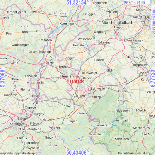
Haanrade GPS coordinates[2]
50° 52' 47.316" North, 6° 4' 26.796" East
| Map corner | latitude | longitude |
|---|---|---|
| Upper-left | 51.32134°, | 5.37098° |
| Center: | 50.87981°, | 6.07411° |
| Lower-right: | 50.43406°, | 6.77723° |
| Map W x H: | 98.7×98.7 km | = 61.3×61.3mi |
| max Lat: | 53.48025° ⇑96.8% North |
| Haanrade: | 50.87981° |
| min Lat: | ⇓3.2% South 50.76917° |
| min Long | Haanrade | max Long |
| 3.38611° | 6.07411° | 7.16528° |
| W 77.8%⇐ | ⇒22.2% E |
Elevation
Elevation of Haanrade is 134 m = 440 ft, and this is 119 m = 390 ft above average elevation for this country.
| Max E: |
203 m = 666 ft | 1.6% |
| Haanrade | 134 m 440 ft | |
| Avg. | 15 m = 49 ft | |
Min E: |
-6 m = -20 ft | 98.4% |
See also: Netherlands elevation on elevation.city.
Geographical zone
Haanrade is located in North temperate zone (between Tropic of Cancer and the Arctic Circle). Distance of this North polar circle is 1743.9 km =1083.6 mi to North.| Distance of | km | miles | from Haanrade |
|---|---|---|---|
| North Pole | 4349.8 | 2702.8 | to North |
| Arctic Circle | 1743.9 | 1083.6 | to North |
| Tropic Cancer | 3051.4 | 1896.1 | to South |
| Equator | 5657.3 | 3515.3 | to South |


Nearby cities:
15 places around Haanrade: (largest is in red/bold)
• Abdissenbosch
5 km =3.1 mi,  325°
325°
• Bleijerheide
2.8 km =1.7 mi,  189°
189°
• Chevremont
1.1 km =0.7 mi,  244°
244°
• Gracht
4.5 km =2.8 mi,  226°
226°
• Groenstraat
3.7 km =2.3 mi, 331°
• Holz
1.7 km =1.1 mi,  179°
179°
• Hopel
2.2 km =1.4 mi,  310°
310°
• Kaalheide
3.1 km =1.9 mi, 238°
• Kerkrade
1.8 km =1.1 mi,  207°
207°
• Lauradorp
4.1 km =2.5 mi, 331°
• Lichtenberg
4.2 km =2.6 mi, 305°
• Rimburg
4.1 km =2.5 mi,  10°
10°
• Spekholzerheide
4.4 km =2.7 mi, 232°
• Terwinselen
3.8 km =2.4 mi,  247°
247°
• Waubach
4.6 km =2.9 mi,  338°
338°
Sources, notices
• [Note1] Compared only with cities in Netherlands existing in our database
• [Src1] Map data: © OpenStreetMap contributors (CC-BY-SA)
• [Src2] Other city data from geonames.org with taken over terms of usage.
• [Src3] Geographical zone / Annual Mean Temperature by Robert A. Rohde @ Wikipedia
