Krooswijk geodata
Krooswijk (North Brabant) is a populated place; located in Netherlands in Europe/Amsterdam (GMT+2) time zone. With population of 4,130 people, there are 576 cities with bigger population in this country. Compared to other cities in Netherlands, 71.7% of cities are located further ↑North; 86.6% of cities are located further →East and 74.9% of cities have higher elevation than Krooswijk. Note1


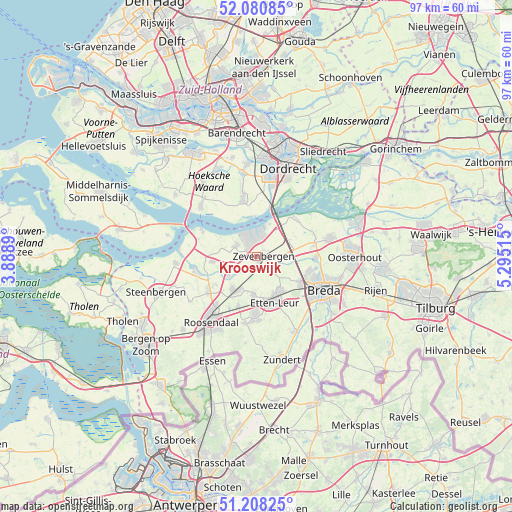
Krooswijk GPS coordinates[2]
51° 38' 47.94" North, 4° 35' 31.308" East
| Map corner | latitude | longitude |
|---|---|---|
| Upper-left | 52.08085°, | 3.8889° |
| Center: | 51.64665°, | 4.59203° |
| Lower-right: | 51.20825°, | 5.29515° |
| Map W x H: | 97×97 km | = 60.3×60.3mi |
| max Lat: | 53.48025° ⇑71.7% North |
| Krooswijk: | 51.64665° |
| min Lat: | ⇓28.3% South 50.76917° |
| min Long | Krooswijk | max Long |
| 3.38611° | 4.59203° | 7.16528° |
| W 13.4%⇐ | ⇒86.6% E |
Elevation
Elevation of Krooswijk is 2 m = 7 ft, and this is 13 m = 43 ft below average elevation for this country.
| Max E: |
203 m = 666 ft | 74.9% |
| Avg. | 15 m = 49 ft | |
| Krooswijk | 2 m = 7 ft | |
Min E: |
-6 m = -20 ft | 25.1% |
See also: Netherlands elevation on elevation.city.
Geographical zone
Krooswijk is located in North temperate zone (between Tropic of Cancer and the Arctic Circle). Distance of this North polar circle is 1658.6 km =1030.6 mi to North.| Distance of | km | miles | from Krooswijk |
|---|---|---|---|
| North Pole | 4264.5 | 2649.8 | to North |
| Arctic Circle | 1658.6 | 1030.6 | to North |
| Tropic Cancer | 3136.7 | 1949.1 | to South |
| Equator | 5742.6 | 3568.3 | to South |


Nearby cities:
15 places around Krooswijk: (largest is in red/bold)
• Bosschenhoofd
10.2 km =6.3 mi,  200°
200°
• Fijnaart
8.5 km =5.3 mi,  263°
263°
• Hoeven
7.5 km =4.7 mi,  184°
184°
• Klundert
4.4 km =2.7 mi,  297°
297°
• Langeweg
5.1 km =3.2 mi,  87°
87°
• Moerdijk
6.6 km =4.1 mi,  21°
21°
• Noordhoek
4.2 km =2.6 mi, 263°
• Prinsenbeek
9.9 km =6.2 mi,  122°
122°
• Sint Willebrord
10.9 km =6.8 mi, 181°
• Stampersgat
10.8 km =6.7 mi,  250°
250°
• Standdaarbuiten
6.5 km =4 mi,  235°
235°
• Stoof
9.5 km =5.9 mi, 236°
• Terheijden
11.2 km =7 mi, 91°
• Wagenberg
11 km =6.8 mi,  79°
79°
• Zevenbergschen Hoek
6.7 km =4.2 mi,  64°
64°
Sources, notices
• [Note1] Compared only with cities in Netherlands existing in our database
• [Src1] Map data: © OpenStreetMap contributors (CC-BY-SA)
• [Src2] Other city data from geonames.org with taken over terms of usage.
• [Src3] Geographical zone / Annual Mean Temperature by Robert A. Rohde @ Wikipedia
