Noordhoek geodata
Noordhoek (North Brabant) is a populated place; located in Netherlands in Europe/Amsterdam (GMT+2) time zone. With population of 1,030 people, there are 1378 cities with bigger population in this country. Compared to other cities in Netherlands, 72% of cities are located further ↑North; 88.3% of cities are located further →East and 83.9% of cities have higher elevation than Noordhoek. Note1


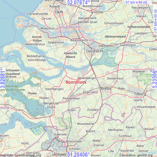
Noordhoek GPS coordinates[2]
51° 38' 33" North, 4° 31' 54.984" East
| Map corner | latitude | longitude |
|---|---|---|
| Upper-left | 52.07674°, | 3.82881° |
| Center: | 51.6425°, | 4.53194° |
| Lower-right: | 51.20406°, | 5.23506° |
| Map W x H: | 97×97 km | = 60.3×60.3mi |
| max Lat: | 53.48025° ⇑72% North |
| Noordhoek: | 51.6425° |
| min Lat: | ⇓28% South 50.76917° |
| min Long | Noordhoek | max Long |
| 3.38611° | 4.53194° | 7.16528° |
| W 11.7%⇐ | ⇒88.3% E |
Elevation
Elevation of Noordhoek is 1 m = 3 ft, and this is 14 m = 46 ft below average elevation for this country.
| Max E: |
203 m = 666 ft | 83.9% |
| Avg. | 15 m = 49 ft | |
| Noordhoek | 1 m = 3 ft | |
Min E: |
-6 m = -20 ft | 16.1% |
See also: Netherlands elevation on elevation.city.
Geographical zone
Noordhoek is located in North temperate zone (between Tropic of Cancer and the Arctic Circle). Distance of this North polar circle is 1659.1 km =1030.9 mi to North.| Distance of | km | miles | from Noordhoek |
|---|---|---|---|
| North Pole | 4265 | 2650.1 | to North |
| Arctic Circle | 1659.1 | 1030.9 | to North |
| Tropic Cancer | 3136.2 | 1948.7 | to South |
| Equator | 5742.1 | 3568 | to South |


Nearby cities:
15 places around Noordhoek: (largest is in red/bold)
• Bosschenhoofd
9.1 km =5.7 mi,  176°
176°
• Fijnaart
4.3 km =2.7 mi,  262°
262°
• Heijningen
8.7 km =5.4 mi,  279°
279°
• Helwijk
7.8 km =4.8 mi,  298°
298°
• Hoeven
7.9 km =4.9 mi,  153°
153°
• Klundert
2.5 km =1.6 mi,  4°
4°
• Krooswijk
4.2 km =2.6 mi,  83°
83°
• Langeweg
9.2 km =5.7 mi,  85°
85°
• Moerdijk
9.3 km =5.8 mi,  44°
44°
• Oud Gastel
8 km =5 mi,  218°
218°
• Stampersgat
6.9 km =4.3 mi,  241°
241°
• Standdaarbuiten
3.5 km =2.2 mi,  201°
201°
• Stoof
6.1 km =3.8 mi, 217°
• Willemstad
8.4 km =5.2 mi,  310°
310°
• Zegge
9.6 km =6 mi,  185°
185°
Sources, notices
• [Note1] Compared only with cities in Netherlands existing in our database
• [Src1] Map data: © OpenStreetMap contributors (CC-BY-SA)
• [Src2] Other city data from geonames.org with taken over terms of usage.
• [Src3] Geographical zone / Annual Mean Temperature by Robert A. Rohde @ Wikipedia
