Standdaarbuiten geodata
Standdaarbuiten (North Brabant) is a populated place; located in Netherlands in Europe/Amsterdam (GMT+2) time zone. With population of 1,930 people, there are 985 cities with bigger population in this country. Compared to other cities in Netherlands, 73.1% of cities are located further ↑North; 88.7% of cities are located further →East and 96.1% of cities have higher elevation than Standdaarbuiten. Note1


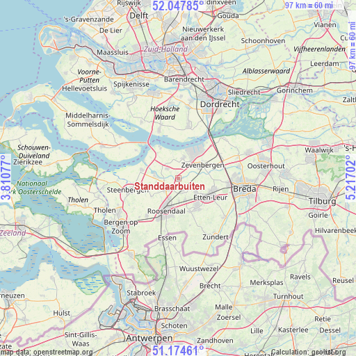
Standdaarbuiten GPS coordinates[2]
51° 36' 47.988" North, 4° 30' 50.004" East
| Map corner | latitude | longitude |
|---|---|---|
| Upper-left | 52.04785°, | 3.81077° |
| Center: | 51.61333°, | 4.51389° |
| Lower-right: | 51.17461°, | 5.21702° |
| Map W x H: | 97.1×97.1 km | = 60.3×60.3mi |
| max Lat: | 53.48025° ⇑73.1% North |
| Standdaarbuiten: | 51.61333° |
| min Lat: | ⇓26.9% South 50.76917° |
| min Long | Standdaarbuiten | max Long |
| 3.38611° | 4.51389° | 7.16528° |
| W 11.3%⇐ | ⇒88.7% E |
Elevation
Elevation of Standdaarbuiten is -1 m = -3 ft, and this is 16 m = 52 ft below average elevation for this country.
| Max E: |
203 m = 666 ft | 96.1% |
| Avg. | 15 m = 49 ft | |
| Standdaarbuiten | -1 m = -3 ft | |
Min E: |
-6 m = -20 ft | 3.9% |
See also: Netherlands elevation on elevation.city.
Geographical zone
Standdaarbuiten is located in North temperate zone (between Tropic of Cancer and the Arctic Circle). Distance of this North polar circle is 1662.3 km =1032.9 mi to North.| Distance of | km | miles | from Standdaarbuiten |
|---|---|---|---|
| North Pole | 4268.2 | 2652.1 | to North |
| Arctic Circle | 1662.3 | 1032.9 | to North |
| Tropic Cancer | 3132.9 | 1946.7 | to South |
| Equator | 5738.9 | 3566 | to South |


Nearby cities:
15 places around Standdaarbuiten: (largest is in red/bold)
• Bosschenhoofd
6.1 km =3.8 mi,  162°
162°
• Fijnaart
4.1 km =2.5 mi,  311°
311°
• Heijningen
8.7 km =5.4 mi,  302°
302°
• Helwijk
9 km =5.6 mi,  320°
320°
• Hoeven
6.1 km =3.8 mi,  128°
128°
• Kalsdonk
8.7 km =5.4 mi,  199°
199°
• Klundert
5.9 km =3.7 mi,  14°
14°
• Krooswijk
6.5 km =4 mi,  55°
55°
• Kruisland
8.7 km =5.4 mi,  235°
235°
• Noordhoek
3.5 km =2.2 mi,  21°
21°
• Oud Gastel
4.8 km =3 mi,  231°
231°
• Sint Willebrord
8.9 km =5.5 mi,  144°
144°
• Stampersgat
4.8 km =3 mi,  270°
270°
• Stoof
2.9 km =1.8 mi, 237°
• Zegge
6.3 km =3.9 mi,  177°
177°
Sources, notices
• [Note1] Compared only with cities in Netherlands existing in our database
• [Src1] Map data: © OpenStreetMap contributors (CC-BY-SA)
• [Src2] Other city data from geonames.org with taken over terms of usage.
• [Src3] Geographical zone / Annual Mean Temperature by Robert A. Rohde @ Wikipedia
