Stoof geodata
Stoof (North Brabant) is a populated place; located in Netherlands in Europe/Amsterdam (GMT+2) time zone. With population of 585 people, there are 1736 cities with bigger population in this country. Compared to other cities in Netherlands, 74% of cities are located further ↑North; 89.9% of cities are located further →East and 83.9% of cities have higher elevation than Stoof. Note1


Stoof GPS coordinates[2]
51° 35' 57.012" North, 4° 28' 40.008" East
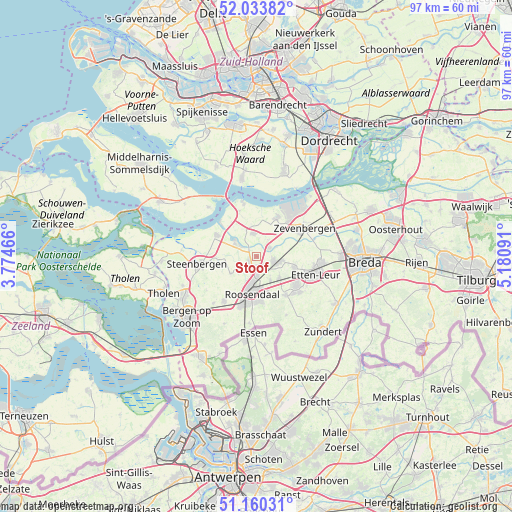
| Map corner | latitude | longitude |
|---|---|---|
| Upper-left | 52.03382°, | 3.77466° |
| Center: | 51.59917°, | 4.47778° |
| Lower-right: | 51.16031°, | 5.18091° |
| Map W x H: | 97.1×97.1 km | = 60.3×60.3mi |
| max Lat: | 53.48025° ⇑74% North |
| Stoof: | 51.59917° |
| min Lat: | ⇓26% South 50.76917° |
| min Long | Stoof | max Long |
| 3.38611° | 4.47778° | 7.16528° |
| W 10.1%⇐ | ⇒89.9% E |
Elevation
Elevation of Stoof is 1 m = 3 ft, and this is 14 m = 46 ft below average elevation for this country.
| Max E: |
203 m = 666 ft | 83.9% |
| Avg. | 15 m = 49 ft | |
| Stoof | 1 m = 3 ft | |
Min E: |
-6 m = -20 ft | 16.1% |
See also: Netherlands elevation on elevation.city.
Geographical zone
Stoof is located in North temperate zone (between Tropic of Cancer and the Arctic Circle). Distance of this North polar circle is 1663.9 km =1033.9 mi to North.| Distance of | km | miles | from Stoof |
|---|---|---|---|
| North Pole | 4269.8 | 2653.1 | to North |
| Arctic Circle | 1663.9 | 1033.9 | to North |
| Tropic Cancer | 3131.4 | 1945.8 | to South |
| Equator | 5737.3 | 3565 | to South |


Nearby cities:
15 places around Stoof: (largest is in red/bold)
• Bosschenhoofd
6.1 km =3.8 mi,  134°
134°
• Dinteloord
8.5 km =5.3 mi,  298°
298°
• Fijnaart
4.3 km =2.7 mi,  352°
352°
• Heijningen
7.9 km =4.9 mi,  322°
322°
• Hoeven
7.6 km =4.7 mi,  106°
106°
• Hulsdonk
8.6 km =5.3 mi,  196°
196°
• Kalsdonk
6.6 km =4.1 mi,  183°
183°
• Klundert
8.3 km =5.2 mi,  28°
28°
• Kruisland
5.8 km =3.6 mi,  234°
234°
• Noordhoek
6.1 km =3.8 mi,  37°
37°
• Oud Gastel
1.9 km =1.2 mi,  221°
221°
• Roosendaal
7.6 km =4.7 mi,  186°
186°
• Stampersgat
2.8 km =1.7 mi, 304°
• Standdaarbuiten
2.9 km =1.8 mi,  57°
57°
• Zegge
5.5 km =3.4 mi,  149°
149°
Sources, notices
• [Note1] Compared only with cities in Netherlands existing in our database
• [Src1] Map data: © OpenStreetMap contributors (CC-BY-SA)
• [Src2] Other city data from geonames.org with taken over terms of usage.
• [Src3] Geographical zone / Annual Mean Temperature by Robert A. Rohde @ Wikipedia
