Kalsdonk geodata
Kalsdonk (North Brabant) is a section of populated place; located in Netherlands in Europe/Amsterdam (GMT+2) time zone. With population of 4,250 people, there are 562 cities with bigger population in this country. Compared to other cities in Netherlands, 77.7% of cities are located further ↑North; 90.1% of cities are located further →East and 50.6% of cities have higher elevation than Kalsdonk. Note1


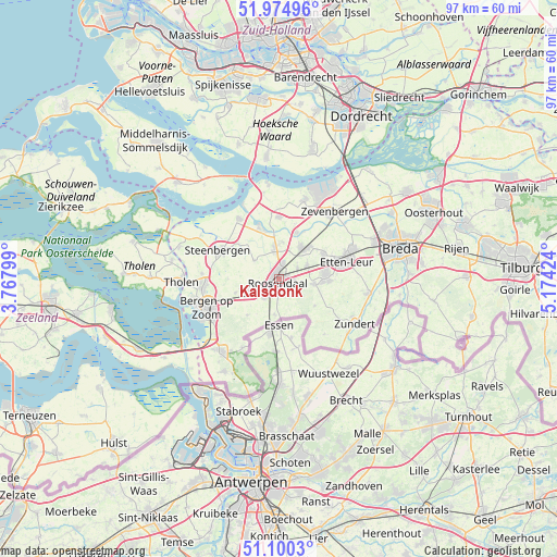
Kalsdonk GPS coordinates[2]
51° 32' 23.028" North, 4° 28' 15.996" East
| Map corner | latitude | longitude |
|---|---|---|
| Upper-left | 51.97496°, | 3.76799° |
| Center: | 51.53973°, | 4.47111° |
| Lower-right: | 51.1003°, | 5.17424° |
| Map W x H: | 97.3×97.3 km | = 60.5×60.5mi |
| max Lat: | 53.48025° ⇑77.7% North |
| Kalsdonk: | 51.53973° |
| min Lat: | ⇓22.3% South 50.76917° |
| min Long | Kalsdonk | max Long |
| 3.38611° | 4.47111° | 7.16528° |
| W 9.9%⇐ | ⇒90.1% E |
Elevation
Elevation of Kalsdonk is 6 m = 20 ft, and this is 9 m = 30 ft below average elevation for this country.
| Max E: |
203 m = 666 ft | 50.6% |
| Avg. | 15 m = 49 ft | |
| Kalsdonk | 6 m = 20 ft | |
Min E: |
-6 m = -20 ft | 49.4% |
See also: Netherlands elevation on elevation.city.
Geographical zone
Kalsdonk is located in North temperate zone (between Tropic of Cancer and the Arctic Circle). Distance of this North polar circle is 1670.5 km =1038 mi to North.| Distance of | km | miles | from Kalsdonk |
|---|---|---|---|
| North Pole | 4276.4 | 2657.2 | to North |
| Arctic Circle | 1670.5 | 1038 | to North |
| Tropic Cancer | 3124.8 | 1941.7 | to South |
| Equator | 5730.7 | 3560.9 | to South |


Nearby cities:
15 places around Kalsdonk: (largest is in red/bold)
• Bosschenhoofd
5.3 km =3.3 mi,  63°
63°
• Heerle
8 km =5 mi,  253°
253°
• Hulsdonk
2.5 km =1.6 mi,  230°
230°
• Kruisland
5.4 km =3.4 mi,  307°
307°
• Nispen
6.3 km =3.9 mi,  186°
186°
• Oud Gastel
5.3 km =3.3 mi,  351°
351°
• Roosendaal
1.1 km =0.7 mi,  202°
202°
• Rucphen
6.1 km =3.8 mi,  98°
98°
• Schijf
7.7 km =4.8 mi,  125°
125°
• Sint Willebrord
8.2 km =5.1 mi,  83°
83°
• Stampersgat
8.4 km =5.2 mi, 347°
• Stoof
6.6 km =4.1 mi,  3°
3°
• Wouw
5.9 km =3.7 mi, 250°
• Wouwse Plantage
8.5 km =5.3 mi,  223°
223°
• Zegge
3.8 km =2.4 mi, 59°
Sources, notices
• [Note1] Compared only with cities in Netherlands existing in our database
• [Src1] Map data: © OpenStreetMap contributors (CC-BY-SA)
• [Src2] Other city data from geonames.org with taken over terms of usage.
• [Src3] Geographical zone / Annual Mean Temperature by Robert A. Rohde @ Wikipedia
