Rucphen geodata
Rucphen (North Brabant) is a populated place; located in Netherlands in Europe/Amsterdam (GMT+2) time zone. With population of 3,660 people, there are 642 cities with bigger population in this country. Compared to other cities in Netherlands, 78.3% of cities are located further ↑North; 87.5% of cities are located further →East and 64.6% of cities have lower elevation than Rucphen. Note1


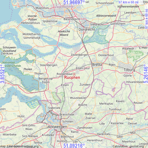
Rucphen GPS coordinates[2]
51° 31' 54.012" North, 4° 33' 29.988" East
| Map corner | latitude | longitude |
|---|---|---|
| Upper-left | 51.96697°, | 3.85521° |
| Center: | 51.53167°, | 4.55833° |
| Lower-right: | 51.09216°, | 5.26146° |
| Map W x H: | 97.3×97.3 km | = 60.5×60.5mi |
| max Lat: | 53.48025° ⇑78.3% North |
| Rucphen: | 51.53167° |
| min Lat: | ⇓21.7% South 50.76917° |
| min Long | Rucphen | max Long |
| 3.38611° | 4.55833° | 7.16528° |
| W 12.5%⇐ | ⇒87.5% E |
Elevation
Elevation of Rucphen is 12 m = 39 ft, and this is 3 m = 10 ft below average elevation for this country.
| Max E: |
203 m = 666 ft | 35.4% |
| Avg. | 15 m = 49 ft | |
| Rucphen | 12 m = 39 ft | |
Min E: |
-6 m = -20 ft | 64.6% |
See also: Netherlands elevation on elevation.city.
Geographical zone
Rucphen is located in North temperate zone (between Tropic of Cancer and the Arctic Circle). Distance of this North polar circle is 1671.4 km =1038.6 mi to North.| Distance of | km | miles | from Rucphen |
|---|---|---|---|
| North Pole | 4277.3 | 2657.8 | to North |
| Arctic Circle | 1671.4 | 1038.6 | to North |
| Tropic Cancer | 3123.9 | 1941.1 | to South |
| Equator | 5729.8 | 3560.3 | to South |


Nearby cities:
15 places around Rucphen: (largest is in red/bold)
• Achtmaal
8.8 km =5.5 mi,  168°
168°
• Bosschenhoofd
3.5 km =2.2 mi,  338°
338°
• Hoeven
5.6 km =3.5 mi,  18°
18°
• Hulsdonk
8 km =5 mi,  264°
264°
• Kalsdonk
6.1 km =3.8 mi,  278°
278°
• Klein-Zundert
8.7 km =5.4 mi,  130°
130°
• Nispen
8.6 km =5.3 mi,  231°
231°
• Oud Gastel
9.2 km =5.7 mi,  311°
311°
• Roosendaal
6.4 km =4 mi,  269°
269°
• Schijf
3.6 km =2.2 mi,  176°
176°
• Sint Willebrord
2.8 km =1.7 mi,  48°
48°
• Sprundel
2.8 km =1.7 mi,  76°
76°
• Stoof
9.3 km =5.8 mi,  323°
323°
• Zegge
3.9 km =2.4 mi, 314°
• Zundert
9.5 km =5.9 mi, 134°
Sources, notices
• [Note1] Compared only with cities in Netherlands existing in our database
• [Src1] Map data: © OpenStreetMap contributors (CC-BY-SA)
• [Src2] Other city data from geonames.org with taken over terms of usage.
• [Src3] Geographical zone / Annual Mean Temperature by Robert A. Rohde @ Wikipedia
