Zegge geodata
Zegge (North Brabant) is a populated place; located in Netherlands in Europe/Amsterdam (GMT+2) time zone. With population of 1,575 people, there are 1099 cities with bigger population in this country. Compared to other cities in Netherlands, 76.6% of cities are located further ↑North; 88.6% of cities are located further →East and 50.6% of cities have higher elevation than Zegge. Note1


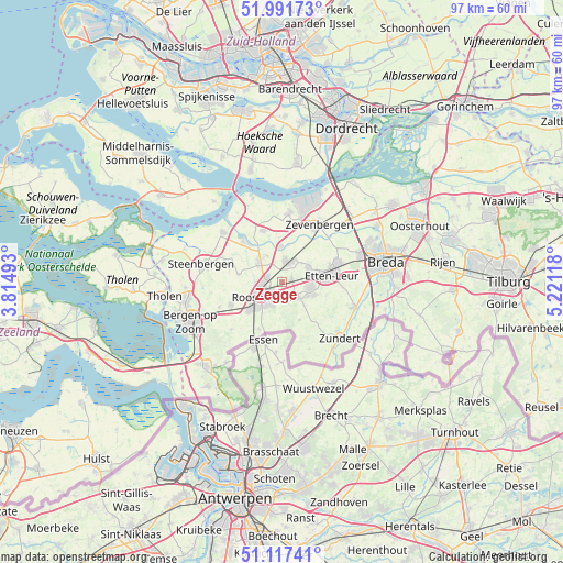
Zegge GPS coordinates[2]
51° 33' 24.012" North, 4° 31' 5.016" East
| Map corner | latitude | longitude |
|---|---|---|
| Upper-left | 51.99173°, | 3.81493° |
| Center: | 51.55667°, | 4.51806° |
| Lower-right: | 51.11741°, | 5.22118° |
| Map W x H: | 97.2×97.2 km | = 60.4×60.4mi |
| max Lat: | 53.48025° ⇑76.6% North |
| Zegge: | 51.55667° |
| min Lat: | ⇓23.4% South 50.76917° |
| min Long | Zegge | max Long |
| 3.38611° | 4.51806° | 7.16528° |
| W 11.4%⇐ | ⇒88.6% E |
Elevation
Elevation of Zegge is 6 m = 20 ft, and this is 9 m = 30 ft below average elevation for this country.
| Max E: |
203 m = 666 ft | 50.6% |
| Avg. | 15 m = 49 ft | |
| Zegge | 6 m = 20 ft | |
Min E: |
-6 m = -20 ft | 49.4% |
See also: Netherlands elevation on elevation.city.
Geographical zone
Zegge is located in North temperate zone (between Tropic of Cancer and the Arctic Circle). Distance of this North polar circle is 1668.6 km =1036.8 mi to North.| Distance of | km | miles | from Zegge |
|---|---|---|---|
| North Pole | 4274.5 | 2656.1 | to North |
| Arctic Circle | 1668.6 | 1036.8 | to North |
| Tropic Cancer | 3126.6 | 1942.8 | to South |
| Equator | 5732.6 | 3562.1 | to South |


Nearby cities:
15 places around Zegge: (largest is in red/bold)
• Bosschenhoofd
1.6 km =1 mi,  73°
73°
• Hoeven
5.2 km =3.2 mi,  60°
60°
• Hulsdonk
6.3 km =3.9 mi,  236°
236°
• Kalsdonk
3.8 km =2.4 mi, 239°
• Kruisland
7.6 km =4.7 mi,  280°
280°
• Nispen
9.1 km =5.7 mi,  205°
205°
• Oud Gastel
5.2 km =3.2 mi,  309°
309°
• Roosendaal
4.6 km =2.9 mi,  231°
231°
• Rucphen
3.9 km =2.4 mi,  134°
134°
• Schijf
7.1 km =4.4 mi,  155°
155°
• Sint Willebrord
5 km =3.1 mi,  100°
100°
• Sprundel
5.9 km =3.7 mi,  111°
111°
• Stampersgat
8.1 km =5 mi,  321°
321°
• Standdaarbuiten
6.3 km =3.9 mi,  357°
357°
• Stoof
5.5 km =3.4 mi,  329°
329°
Sources, notices
• [Note1] Compared only with cities in Netherlands existing in our database
• [Src1] Map data: © OpenStreetMap contributors (CC-BY-SA)
• [Src2] Other city data from geonames.org with taken over terms of usage.
• [Src3] Geographical zone / Annual Mean Temperature by Robert A. Rohde @ Wikipedia
