Hoeven geodata
Hoeven (North Brabant) is a populated locality; located in Netherlands in Europe/Amsterdam (GMT+2) time zone. With population of 1,960 people, there are 972 cities with bigger population in this country. Compared to other cities in Netherlands, 70.3% of cities are located further ↑North; 50.7% of cities are located further →East and 81.4% of cities have lower elevation than Hoeven. Note1


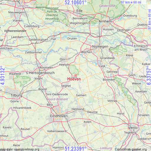
Hoeven GPS coordinates[2]
51° 40' 19.416" North, 5° 38' 3.984" East
| Map corner | latitude | longitude |
|---|---|---|
| Upper-left | 52.10601°, | 4.93132° |
| Center: | 51.67206°, | 5.63444° |
| Lower-right: | 51.23391°, | 6.33757° |
| Map W x H: | 97×97 km | = 60.3×60.3mi |
| max Lat: | 53.48025° ⇑70.3% North |
| Hoeven: | 51.67206° |
| min Lat: | ⇓29.7% South 50.76917° |
| min Long | Hoeven | max Long |
| 3.38611° | 5.63444° | 7.16528° |
| W 49.3%⇐ | ⇒50.7% E |
Elevation
Elevation of Hoeven is 22 m = 72 ft, and this is 7 m = 23 ft above average elevation for this country.
| Max E: |
203 m = 666 ft | 18.6% |
| Hoeven | 22 m 72 ft | |
| Avg. | 15 m = 49 ft | |
Min E: |
-6 m = -20 ft | 81.4% |
See also: Netherlands elevation on elevation.city.
Geographical zone
Hoeven is located in North temperate zone (between Tropic of Cancer and the Arctic Circle). Distance of this North polar circle is 1655.8 km =1028.9 mi to North.| Distance of | km | miles | from Hoeven |
|---|---|---|---|
| North Pole | 4261.7 | 2648.1 | to North |
| Arctic Circle | 1655.8 | 1028.9 | to North |
| Tropic Cancer | 3139.5 | 1950.8 | to South |
| Equator | 5745.4 | 3570 | to South |


Nearby cities:
15 places around Hoeven: (largest is in red/bold)
• Bitswijk
1.8 km =1.1 mi,  257°
257°
• Boekel
8.1 km =5 mi,  159°
159°
• Eikenheuvel
4 km =2.5 mi,  203°
203°
• Erp
8.2 km =5.1 mi,  193°
193°
• Langenboom
7.5 km =4.7 mi,  61°
61°
• Mariaheide
5.7 km =3.5 mi,  220°
220°
• Melle
1.1 km =0.7 mi,  182°
182°
• Nistelrode
6.1 km =3.8 mi,  305°
305°
• Odiliapeel
5.9 km =3.7 mi,  123°
123°
• Raam
1.4 km =0.9 mi,  174°
174°
• Uden
1.6 km =1 mi, 219°
• Ven
6.8 km =4.2 mi,  238°
238°
• Volkel
3.6 km =2.2 mi, 157°
• Vorstenbosch
6.2 km =3.9 mi,  249°
249°
• Zeeland
4 km =2.5 mi,  45°
45°
Sources, notices
• [Note1] Compared only with cities in Netherlands existing in our database
• [Src1] Map data: © OpenStreetMap contributors (CC-BY-SA)
• [Src2] Other city data from geonames.org with taken over terms of usage.
• [Src3] Geographical zone / Annual Mean Temperature by Robert A. Rohde @ Wikipedia
