Odiliapeel geodata
Odiliapeel (North Brabant) is a populated place; located in Netherlands in Europe/Amsterdam (GMT+2) time zone. With population of 1,390 people, there are 1187 cities with bigger population in this country. Compared to other cities in Netherlands, 71.9% of cities are located further ↑North; 51.9% of cities are located further ←West and 82.1% of cities have lower elevation than Odiliapeel. Note1


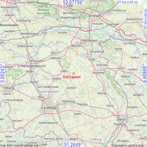
Odiliapeel GPS coordinates[2]
51° 38' 35.988" North, 5° 42' 20.016" East
| Map corner | latitude | longitude |
|---|---|---|
| Upper-left | 52.07756°, | 5.00243° |
| Center: | 51.64333°, | 5.70556° |
| Lower-right: | 51.2049°, | 6.40868° |
| Map W x H: | 97×97 km | = 60.3×60.3mi |
| max Lat: | 53.48025° ⇑71.9% North |
| Odiliapeel: | 51.64333° |
| min Lat: | ⇓28.1% South 50.76917° |
| min Long | Odiliapeel | max Long |
| 3.38611° | 5.70556° | 7.16528° |
| W 51.9%⇐ | ⇒48.1% E |
Elevation
Elevation of Odiliapeel is 23 m = 75 ft, and this is 8 m = 26 ft above average elevation for this country.
| Max E: |
203 m = 666 ft | 17.9% |
| Odiliapeel | 23 m 75 ft | |
| Avg. | 15 m = 49 ft | |
Min E: |
-6 m = -20 ft | 82.1% |
See also: Netherlands elevation on elevation.city.
Geographical zone
Odiliapeel is located in North temperate zone (between Tropic of Cancer and the Arctic Circle). Distance of this North polar circle is 1659 km =1030.9 mi to North.| Distance of | km | miles | from Odiliapeel |
|---|---|---|---|
| North Pole | 4264.9 | 2650.1 | to North |
| Arctic Circle | 1659 | 1030.9 | to North |
| Tropic Cancer | 3136.3 | 1948.8 | to South |
| Equator | 5742.2 | 3568 | to South |


Nearby cities:
15 places around Odiliapeel: (largest is in red/bold)
• Bitswijk
7.2 km =4.5 mi,  292°
292°
• Boekel
4.9 km =3 mi,  205°
205°
• Eikenheuvel
6.5 km =4 mi,  265°
265°
• Handel
7 km =4.3 mi,  177°
177°
• Hoeven
5.9 km =3.7 mi,  303°
303°
• Langenboom
7 km =4.3 mi,  14°
14°
• Melle
5.4 km =3.4 mi, 293°
• Raam
5.1 km =3.2 mi, 290°
• Sint Hubert
8.1 km =5 mi,  61°
61°
• Uden
6.3 km =3.9 mi, 288°
• Venhorst
4.5 km =2.8 mi,  150°
150°
• Volkel
3.5 km =2.2 mi, 268°
• Wanroij
7.9 km =4.9 mi,  78°
78°
• Wilbertoord
5 km =3.1 mi,  73°
73°
• Zeeland
6.4 km =4 mi,  341°
341°
Sources, notices
• [Note1] Compared only with cities in Netherlands existing in our database
• [Src1] Map data: © OpenStreetMap contributors (CC-BY-SA)
• [Src2] Other city data from geonames.org with taken over terms of usage.
• [Src3] Geographical zone / Annual Mean Temperature by Robert A. Rohde @ Wikipedia
